IMAGES TAKEN NEAR TO
Priory Close, BARNSLEY, S70 5LX
Introduction
This page details the photographs taken nearby to Priory Close, S70 5LX by members of the Geograph project.
The Geograph project started in 2005 with the aim of publishing, organising and preserving representative images for every square kilometre of Great Britain, Ireland and the Isle of Man.

There are currently over 7.5m images from over14,400 individuals and you can help contribute to the project by visiting https://www.geograph.org.uk
Image Map (Loading...)


Getting Data...Please wait
Leaflet Map data © OpenStreetMap
Images are licensed for reuse under creativecommons.org/licenses/by-sa/2.0
Notes
- Clicking on the map will re-center to the selected point.
- The higher the marker number, the further away the image location is from the centre of the postcode.
Image Listing (31 Images Found)
Images are licensed for reuse under creativecommons.org/licenses/by-sa/2.0
Image
Details
Distance
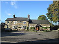
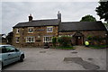
3
The Edmunds Arms public house
A Sam Smith's pub in Worsbrough.
Image: © Ian S
Taken: 31 May 2014
0.07 miles
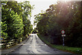
7
Traffic lights in Worsbrough village
The Edmunds Arms public house is on the left.
Image: © Steve Fareham
Taken: 12 Oct 2007
0.08 miles
8
The Edmunds Arms public house
A Sam Smiths pub in Worsbrough.
Image: © Ian S
Taken: 31 May 2014
0.08 miles
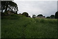
9
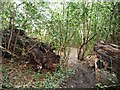
Public footpath through a fallen tree, Worsbrough
Heading north to Worsbrough Road. Rather than moving the fallen tree, a slice has been sawn out of it.
Image: © Christine Johnstone
Taken: 19 Mar 2016
0.08 miles