IMAGES TAKEN NEAR TO
Spring Vale Avenue, BARNSLEY, S70 5JU
Introduction
This page details the photographs taken nearby to Spring Vale Avenue, S70 5JU by members of the Geograph project.
The Geograph project started in 2005 with the aim of publishing, organising and preserving representative images for every square kilometre of Great Britain, Ireland and the Isle of Man.

There are currently over 7.5m images from over14,400 individuals and you can help contribute to the project by visiting https://www.geograph.org.uk
Image Map
Images are licensed for reuse under creativecommons.org/licenses/by-sa/2.0
Notes
- Clicking on the map will re-center to the selected point.
- The higher the marker number, the further away the image location is from the centre of the postcode.
Image Listing (19 Images Found)
Images are licensed for reuse under creativecommons.org/licenses/by-sa/2.0
Image
Details
Distance
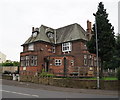
1
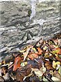
Benchmark Marrow House
Cut benchmark on roadside wall outside Marrow House, Vernon Road https://www.bench-marks.org.uk/bm135063
Image: © Kevan Goldsby-West
Taken: 2 Nov 2020
0.09 miles
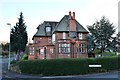
2
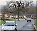
Haverlands Lane, Worsbrough
Seen from the end of the footpath that leads towards Worsbrough Mill.
Image: © Paul Harrop
Taken: 13 Dec 2016
0.13 miles
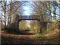
5
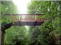
Footbridge over the Trans Pennine Trail.
Image: © Steve Fareham
Taken: 2 Sep 2007
0.19 miles
7
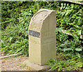
Only 100km to Hull.
Marker on the Trans Pennine Trail.
Image: © Steve Fareham
Taken: 2 Sep 2007
0.19 miles
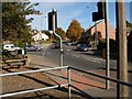
8
Footbridge over the Trans Pennine Trail near Worsbrough Bridge
Image: © John Slater
Taken: 23 Nov 2012
0.20 miles
9
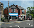
Shops, Park Road, Worsbrough
No.63 is Worsbrough Dental Practice and No.65 Biketyke cycle shop.
Image: © Humphrey Bolton
Taken: 8 Jun 2021
0.21 miles