IMAGES TAKEN NEAR TO
Greystones Avenue, BARNSLEY, S70 5JF
Introduction
This page details the photographs taken nearby to Greystones Avenue, S70 5JF by members of the Geograph project.
The Geograph project started in 2005 with the aim of publishing, organising and preserving representative images for every square kilometre of Great Britain, Ireland and the Isle of Man.

There are currently over 7.5m images from over14,400 individuals and you can help contribute to the project by visiting https://www.geograph.org.uk
Image Map
Images are licensed for reuse under creativecommons.org/licenses/by-sa/2.0
Notes
- Clicking on the map will re-center to the selected point.
- The higher the marker number, the further away the image location is from the centre of the postcode.
Image Listing (11 Images Found)
Images are licensed for reuse under creativecommons.org/licenses/by-sa/2.0
Image
Details
Distance
2
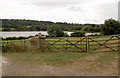
Gate with Worsbrough reservoir behind
River Dove dammed to form reservoir.
Image: © Steve Fareham
Taken: 2 Sep 2007
0.22 miles
3
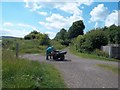
The Trans Pennine Trail near Worsbrough Reservoir
These anglers are wheeling their fishing equipment up from the reservoir on improvised carts.
Image: © Jonathan Clitheroe
Taken: 27 Jun 2015
0.22 miles
4
![Turn right [north] for Wingfield Farm](https://s2.geograph.org.uk/geophotos/04/87/09/4870934_5fad59c7_120x120.jpg)
Turn right [north] for Wingfield Farm's attractions
The Trans Pennine Trail near Worsbrough Reservoir. This path was built as a railway to Silkstone Moor End, and later became part of the electrified Woodhead line, closing in 1981.
Image: © Christine Johnstone
Taken: 19 Mar 2016
0.23 miles
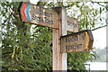
6
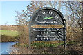
TPT sign at Kendal Green
A Trans Pennine Trail (TPT) sign on the Dove Valley Trail at Kendal Green, Barnsley.
Image: © Dave Pickersgill
Taken: 7 Jan 2014
0.24 miles
7
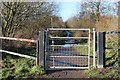
Gate on the Trail
A gate on the Trans Pennine Trail (TPT) (Dove Valley Trail) at Kendal Green, Barnsley.
Image: © Dave Pickersgill
Taken: 7 Jan 2014
0.24 miles
9
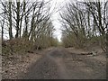
The Trans Pennine Trail, Worsbrough, looking west
Also the Dove Valley Trail. This was built as a railway to Silkstone Moor End, and later became part of the electrified Woodhead line, closing in 1981.
Image: © Christine Johnstone
Taken: 19 Mar 2016
0.25 miles
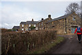
10
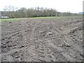
Muddy field entrance south of Wingfield Farm
About 65 metres above sea level.
Image: © Christine Johnstone
Taken: 19 Mar 2016
0.25 miles