IMAGES TAKEN NEAR TO
High Ridge, BARNSLEY, S70 5HL
Introduction
This page details the photographs taken nearby to High Ridge, S70 5HL by members of the Geograph project.
The Geograph project started in 2005 with the aim of publishing, organising and preserving representative images for every square kilometre of Great Britain, Ireland and the Isle of Man.

There are currently over 7.5m images from over14,400 individuals and you can help contribute to the project by visiting https://www.geograph.org.uk
Image Map
Images are licensed for reuse under creativecommons.org/licenses/by-sa/2.0
Notes
- Clicking on the map will re-center to the selected point.
- The higher the marker number, the further away the image location is from the centre of the postcode.
Image Listing (7 Images Found)
Images are licensed for reuse under creativecommons.org/licenses/by-sa/2.0
Image
Details
Distance
1
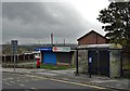
On Vernon Road near Ward Green Pharmacy
Image: © Neil Theasby
Taken: 21 Oct 2017
0.05 miles
2
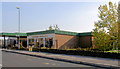
Furniture interiors
Former garage. I think Audi had one of their first dealership here over 30 years ago.
Image: © Steve Fareham
Taken: 23 Oct 2007
0.10 miles
3
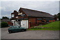
Ward Green WMC on Mount Vernon Road
A committee run Sam Smith's owned club.
Image: © Ian S
Taken: 31 May 2014
0.16 miles
4
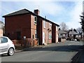
Houses on the north side of Strafford Avenue
Unusual double-fronted semis in the Ward Green area of Worsbrough.
Image: © Christine Johnstone
Taken: 9 Mar 2018
0.24 miles
5
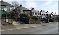
Semis stepping down Highstone Lane, Ward Green
The roofs are level in each pair of houses, but the windows are not.
Image: © Christine Johnstone
Taken: 9 Mar 2018
0.24 miles
6
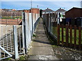
Footpath from Strafford Avenue to Highstone Lane
Securely fenced on both sides.
Image: © Christine Johnstone
Taken: 9 Mar 2018
0.24 miles
7
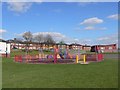
Children's playground at Ward Green
The houses on this estate benefit from wide open views across Worsbrough Reservoir and the Dove Valley. St Mary's church spire can be glimpsed through the trees to the south.
Image: © Wendy North
Taken: 16 Apr 2006
0.25 miles