IMAGES TAKEN NEAR TO
Highstone Avenue, BARNSLEY, S70 4LA
Introduction
This page details the photographs taken nearby to Highstone Avenue, S70 4LA by members of the Geograph project.
The Geograph project started in 2005 with the aim of publishing, organising and preserving representative images for every square kilometre of Great Britain, Ireland and the Isle of Man.

There are currently over 7.5m images from over14,400 individuals and you can help contribute to the project by visiting https://www.geograph.org.uk
Image Map
Images are licensed for reuse under creativecommons.org/licenses/by-sa/2.0
Notes
- Clicking on the map will re-center to the selected point.
- The higher the marker number, the further away the image location is from the centre of the postcode.
Image Listing (8 Images Found)
Images are licensed for reuse under creativecommons.org/licenses/by-sa/2.0
Image
Details
Distance
1
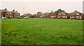
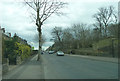
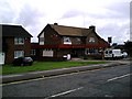
Open spaces
Green open space in housing estate off Warren Quarry Lane.
Image: © Steve Fareham
Taken: 13 Oct 2007
0.17 miles
2
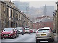
Castle Street, Barnsley
Looking north down the street from close to its junction with Park Road - buildings in the town centre visible in the distance.
Image: © Paul Harrop
Taken: 13 Dec 2016
0.18 miles
6
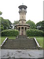
Locke Park Tower, Barnsley
21m high belvedere tower, with an Italianate tower above a circular Ionic colonnade. 1877
Image: © Arthur Hill
Taken: 30 May 2011
0.24 miles
7
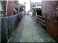
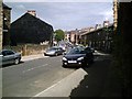
Cobbled alley, from Locke Avenue to Park Grove
Image: © Peter Beard
Taken: 21 Jun 2007
0.25 miles
8
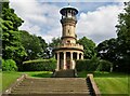
Locke Park Tower
An 1877 memorial tower to Mrs Phoebe Locke, widow of Joseph Locke, one of the early railway civil engineers
Image: © Kevin Waterhouse
Taken: 14 Jul 2012
0.25 miles