IMAGES TAKEN NEAR TO
Cork Lane, BARNSLEY, S70 3QG
Introduction
This page details the photographs taken nearby to Cork Lane, S70 3QG by members of the Geograph project.
The Geograph project started in 2005 with the aim of publishing, organising and preserving representative images for every square kilometre of Great Britain, Ireland and the Isle of Man.

There are currently over 7.5m images from over14,400 individuals and you can help contribute to the project by visiting https://www.geograph.org.uk
Image Map
Images are licensed for reuse under creativecommons.org/licenses/by-sa/2.0
Notes
- Clicking on the map will re-center to the selected point.
- The higher the marker number, the further away the image location is from the centre of the postcode.
Image Listing (7 Images Found)
Images are licensed for reuse under creativecommons.org/licenses/by-sa/2.0
Image
Details
Distance
1
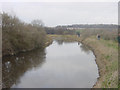
Dearne and Dove Canal near Stairfoot
A short section of the disused Dearne and Dove Canal, still in water, close to Cork Bridge, Stairfoot, near Barnsley, South Yorkshire.
Image: © Martin Clark
Taken: Unknown
0.03 miles
2
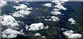
Wombwell and Brampton from the air
Swaithe is in the foreground.
Viewed from a Manchester bound flight from Prague.
Image: © Thomas Nugent
Taken: 18 Apr 2014
0.03 miles
4
![The former Worsbrough branch, Dearne & Dove Canal [5]](https://s0.geograph.org.uk/geophotos/05/21/54/5215416_41676c5d_120x120.jpg)
The former Worsbrough branch, Dearne & Dove Canal [5]
Looking west, near Swaithe Wood.
Image: © Christine Johnstone
Taken: 3 Dec 2016
0.21 miles
5
![The former Worsbrough branch, Dearne & Dove Canal [4]](https://s2.geograph.org.uk/geophotos/05/21/54/5215406_8c8b5c68_120x120.jpg)
The former Worsbrough branch, Dearne & Dove Canal [4]
North-east of Swaithe Bridge. The Worsbrough branch closed in 1906. The hedge [and the public footpath alongside] marks the route of the towpath.
Image: © Christine Johnstone
Taken: 3 Dec 2016
0.21 miles
6
![The former Worsbrough branch, Dearne & Dove Canal [6]](https://s1.geograph.org.uk/geophotos/05/21/54/5215421_9eb266f4_120x120.jpg)
The former Worsbrough branch, Dearne & Dove Canal [6]
South-east of Swaithe Wood. Not infilled and still holding water. The Worsbrough branch closed in 1906.
Image: © Christine Johnstone
Taken: 3 Dec 2016
0.22 miles
7
![The former Worsbrough branch, Dearne & Dove Canal [7]](https://s0.geograph.org.uk/geophotos/05/21/54/5215428_b387cb9a_120x120.jpg)
The former Worsbrough branch, Dearne & Dove Canal [7]
The towpath is a public footpath. The Worsbrough branch closed in 1906.
Image: © Christine Johnstone
Taken: 3 Dec 2016
0.23 miles