IMAGES TAKEN NEAR TO
Wombwell Lane, BARNSLEY, S70 3PB
Introduction
This page details the photographs taken nearby to Wombwell Lane, S70 3PB by members of the Geograph project.
The Geograph project started in 2005 with the aim of publishing, organising and preserving representative images for every square kilometre of Great Britain, Ireland and the Isle of Man.

There are currently over 7.5m images from over14,400 individuals and you can help contribute to the project by visiting https://www.geograph.org.uk
Image Map
Images are licensed for reuse under creativecommons.org/licenses/by-sa/2.0
Notes
- Clicking on the map will re-center to the selected point.
- The higher the marker number, the further away the image location is from the centre of the postcode.
Image Listing (20 Images Found)
Images are licensed for reuse under creativecommons.org/licenses/by-sa/2.0
Image
Details
Distance
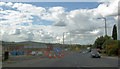
1
New retail unit in the course of construction.
Image: © Steve Fareham
Taken: 6 Sep 2007
0.02 miles
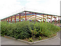
4
Roadworks for construction of new retail unit.
Former site of Polar motor trucks. This shed has been under construction for what seems like years.
Image: © Steve Fareham
Taken: 6 Sep 2007
0.03 miles
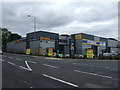
5
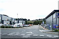
Retail units, Wombwell Lane, Stairfoot
Off the A633.
Image: © JThomas
Taken: 27 Sep 2014
0.03 miles
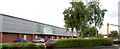
7

Halfords autocentre on Wombwell Lane A633
Image: © Steve Fareham
Taken: 16 Feb 2015
0.05 miles
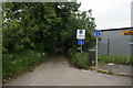
9
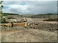
Quarry at the side of the A633 Stairfoot
Image: © John Fielding
Taken: 19 Jul 2008
0.06 miles