IMAGES TAKEN NEAR TO
Wombwell Lane, BARNSLEY, S70 3NX
Introduction
This page details the photographs taken nearby to Wombwell Lane, S70 3NX by members of the Geograph project.
The Geograph project started in 2005 with the aim of publishing, organising and preserving representative images for every square kilometre of Great Britain, Ireland and the Isle of Man.

There are currently over 7.5m images from over14,400 individuals and you can help contribute to the project by visiting https://www.geograph.org.uk
Image Map
Images are licensed for reuse under creativecommons.org/licenses/by-sa/2.0
Notes
- Clicking on the map will re-center to the selected point.
- The higher the marker number, the further away the image location is from the centre of the postcode.
Image Listing (26 Images Found)
Images are licensed for reuse under creativecommons.org/licenses/by-sa/2.0
Image
Details
Distance
1
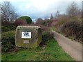
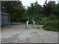
Trans Pennine Trail Commemorative Stone
The stone marks the occasion and the fact that, at this place on 17th July 1996, the Trans Pennine Trail was opened as the first ever British section of a European Long Distance Footpath - no. 8 (E8). It's a shame that the local scroats have defaced it and the Trail custodians have not maintained it.
Image: © Graham Hogg
Taken: 11 Jan 2012
0.01 miles
2
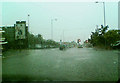
Summer deluge.
On the road from Stairfoot towards Tesco, lasting only minutes the deluge of rain caused instant flooding and chaos.
Image: © Steve Fareham
Taken: 23 Jul 2007
0.01 miles
4
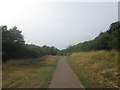
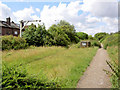
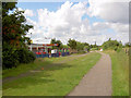
Trans Pennine Trail, Stairfoot
On a disused railway off Wombwell Lane.
Image: © JThomas
Taken: 27 Sep 2014
0.05 miles
6
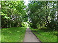
Trans Pennine trail half way marker.
Long distance trail from Southport to Hornsea.
Image: © Steve Fareham
Taken: 22 Jul 2007
0.08 miles
7
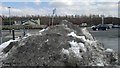
Ardsley (Stairfoot 1st) railway station (site), Yorkshire
Opened in 1851 As "Ardsley" by the South Yorkshire Railway, later part of the Manchester Sheffield & Lincolnshire Railway, on the line from Doncaster to Barnsley. The station was renamed "Stairfoot" in 1870 but then closed a little over a year later when it was replaced by another, immediately behind the camera position.
View south east along the track-bed towards Wombwell Central and Doncaster. No trace of the station now remains and it is a public footpath.
Image: © Nigel Thompson
Taken: 11 Jul 2020
0.09 miles
8
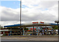
Tesco petrol station.
Tesco has another store 4 miles east at Wath.
Image: © Steve Fareham
Taken: 15 Aug 2007
0.10 miles
9
McDonald's on Trans Pennine trail Stairfoot.
Is this the only cycle through McDonald's on the trail?
Image: © Steve Fareham
Taken: 22 Jul 2007
0.10 miles