IMAGES TAKEN NEAR TO
Summer Lane, BARNSLEY, S70 2NP
Introduction
This page details the photographs taken nearby to Summer Lane, S70 2NP by members of the Geograph project.
The Geograph project started in 2005 with the aim of publishing, organising and preserving representative images for every square kilometre of Great Britain, Ireland and the Isle of Man.

There are currently over 7.5m images from over14,400 individuals and you can help contribute to the project by visiting https://www.geograph.org.uk
Image Map
Images are licensed for reuse under creativecommons.org/licenses/by-sa/2.0
Notes
- Clicking on the map will re-center to the selected point.
- The higher the marker number, the further away the image location is from the centre of the postcode.
Image Listing (41 Images Found)
Images are licensed for reuse under creativecommons.org/licenses/by-sa/2.0
Image
Details
Distance
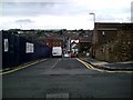
3

Tarnend!
Townend roundabout with building work on the new Barnsley Gateway Plaza complex.
Image: © Steve Fareham
Taken: 6 Sep 2007
0.10 miles
5
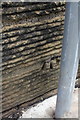
Benchmark on Sackville Street wall
Ordnance Survey cut mark benchmark described on the Bench Mark Database at http://www.bench-marks.org.uk/bm39174
Image: © Roger Templeman
Taken: 13 Aug 2011
0.12 miles
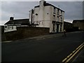
6
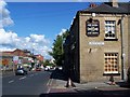
The Marlborough, Barnsley
On the corner of Lancaster Street and Dodworth Road.
Image: © Geoff Pick
Taken: 21 May 2009
0.13 miles
7

Benchmark on side of #74 Sackville Street (Summer Street)
Ordnance Survey cut mark bench mark described on the Bench Mark Database at http://www.bench-marks.org.uk/bm39216
Image: © Roger Templeman
Taken: 13 Aug 2011
0.13 miles
10
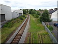
Summer Lane railway station (site), Yorkshire
Opened in 1850 by the South Yorkshire Railway, later part of the Manchester Sheffield & Lincolnshire Railway, on the line from Penistone to Barnsley, this station closed to passengers in 1959 and was demolished.
View north east towards Barnsley. When it was open, there were two tracks and two parallel curved platforms here. The main building would have been on the right of the image.
Image: © Nigel Thompson
Taken: 11 Jul 2020
0.14 miles