IMAGES TAKEN NEAR TO
Park Street, BARNSLEY, S70 1QZ
Introduction
This page details the photographs taken nearby to Park Street, S70 1QZ by members of the Geograph project.
The Geograph project started in 2005 with the aim of publishing, organising and preserving representative images for every square kilometre of Great Britain, Ireland and the Isle of Man.

There are currently over 7.5m images from over14,400 individuals and you can help contribute to the project by visiting https://www.geograph.org.uk
Image Map
Images are licensed for reuse under creativecommons.org/licenses/by-sa/2.0
Notes
- Clicking on the map will re-center to the selected point.
- The higher the marker number, the further away the image location is from the centre of the postcode.
Image Listing (24 Images Found)
Images are licensed for reuse under creativecommons.org/licenses/by-sa/2.0
Image
Details
Distance
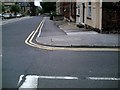
2
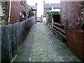
Cobbled alley, from Locke Avenue to Park Grove
Image: © Peter Beard
Taken: 21 Jun 2007
0.06 miles
3
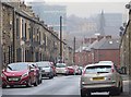
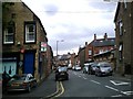
Castle Street, Barnsley
Looking north down the street from close to its junction with Park Road - buildings in the town centre visible in the distance.
Image: © Paul Harrop
Taken: 13 Dec 2016
0.08 miles
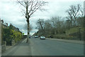
5
The top of Castlereigh St. looking towards town centre
Image: © Peter Beard
Taken: 26 Jun 2007
0.10 miles
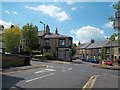
7
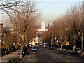
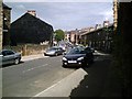
Locke Avenue below the junction with Park Road
The white building centre is Barnsley Town Hall.
Image: © John Fielding
Taken: 20 Jan 2011
0.11 miles
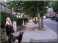
9
Agnes Road from bottom of Hawthorne St. Barnsley
Image: © Peter Beard
Taken: 21 Jun 2007
0.11 miles
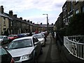
10
Barnsley Street Scene
Agnes Road seen here joining Park Grove.
Image: © Jonathan Clitheroe
Taken: 27 Jun 2015
0.12 miles