IMAGES TAKEN NEAR TO
The Chase, SHEFFIELD, S6 6SW
Introduction
This page details the photographs taken nearby to The Chase, S6 6SW by members of the Geograph project.
The Geograph project started in 2005 with the aim of publishing, organising and preserving representative images for every square kilometre of Great Britain, Ireland and the Isle of Man.

There are currently over 7.5m images from over14,400 individuals and you can help contribute to the project by visiting https://www.geograph.org.uk
Image Map
Images are licensed for reuse under creativecommons.org/licenses/by-sa/2.0
Notes
- Clicking on the map will re-center to the selected point.
- The higher the marker number, the further away the image location is from the centre of the postcode.
Image Listing (63 Images Found)
Images are licensed for reuse under creativecommons.org/licenses/by-sa/2.0
Image
Details
Distance
1
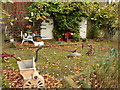
Ploughs and oil cake breaker
Colourful collection of old agricultural implements at Loxley, Sheffield.
Image: © Peter Barr
Taken: 10 Oct 2011
0.03 miles
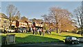
2
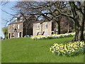
The green at Loxley
A small area of green space at the junction of Loxley Road and Rodney Hill, alive with daffodils. This was the heart of old Loxley before the spread of housing. The further tree is a copper beech planted to commemorate the Silver Jubilee of King George V in 1935.
Image: © Alan Murray-Rust
Taken: 27 Mar 2012
0.04 miles
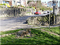
3
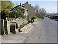
Drinking troughs at Loxley
There were clearly a series of troughs provided along Loxley Road - another survives at Stacey Bank http://www.geograph.org.uk/photo/2872934. The hilly nature of the area would have meant hard work for draught horses, and it was presumably also a drove road for sheep and cattle.
Image: © Alan Murray-Rust
Taken: 27 Mar 2012
0.04 miles
4
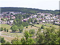
Rodney Hill from Acorn Drive.
The view over Loxley Cemetery towards Rodney Hill as seen from Acorn Drive, near the junction of Golden Oak Dell, Stannington. Submitted to the BBC Domesday Reloaded project. http://www.bbc.co.uk/history/domesday/dblock/GB-428000-390000/picture/1 For another BBC Domesday Reloaded project image see Image
Image: © Martin Speck
Taken: 14 Jun 2011
0.04 miles
5
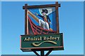
Admiral Rodney, Loxley - 3
Was it ever this sunny this year? Whilst very close to Wisewood Cemetery, this famous old inn is actually in Loxley ... Image Image
Image: © Terry Robinson
Taken: 21 Oct 2008
0.04 miles
6
Percy Pud 10k runners and supporters get ready
Image: © Chris Morgan
Taken: 1 Dec 2013
0.05 miles
7
The green at Loxley
A small area of green space at the junction of Loxley Road and Rodney Hill, alive with daffodils, it was the centre of the original village. The signed bridleway simply cuts off the triangle between the two roads.
Image: © Alan Murray-Rust
Taken: 27 Mar 2012
0.05 miles
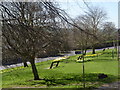
8
Mounting block, Loxley
On the village green, conveniently placed adjacent to a public bridleway - which is all of 50 metres long!
Image: © Alan Murray-Rust
Taken: 27 Mar 2012
0.05 miles
9
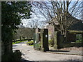
Wisewood Cemetery gates
The entrance to the cemetery is certainly at Loxley, but it seems that the name Wisewood applies to the area nearer the bottom of the valley, which is where the main cemetery area is. The gateposts and the front of the lodge show distinctive Art Deco styling.
Image: © Alan Murray-Rust
Taken: 27 Mar 2012
0.06 miles
10
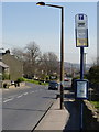
Drivers Switch Off Engines
The service 14 bus route terminates in a long one-way loop around Wisewood and Loxley. This is the formal terminal point, where drivers may have time to wait before returning to Sheffield.
Image: © Alan Murray-Rust
Taken: 27 Mar 2012
0.06 miles