IMAGES TAKEN NEAR TO
Studfield Hill, SHEFFIELD, S6 6RY
Introduction
This page details the photographs taken nearby to Studfield Hill, S6 6RY by members of the Geograph project.
The Geograph project started in 2005 with the aim of publishing, organising and preserving representative images for every square kilometre of Great Britain, Ireland and the Isle of Man.

There are currently over 7.5m images from over14,400 individuals and you can help contribute to the project by visiting https://www.geograph.org.uk
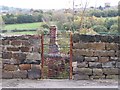
Image Map
Images are licensed for reuse under creativecommons.org/licenses/by-sa/2.0
Notes
- Clicking on the map will re-center to the selected point.
- The higher the marker number, the further away the image location is from the centre of the postcode.
Image Listing (64 Images Found)
Images are licensed for reuse under creativecommons.org/licenses/by-sa/2.0
Image
Details
Distance
1
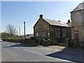
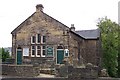
Loxley Methodist Church
An inscribed stone over the central window describes it as a Chapel, with a date of 1885.
Image: © Alan Murray-Rust
Taken: 27 Mar 2012
0.04 miles
2
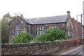
Loxley Methodist Church, Loxley Road, Loxley, Sheffield - 3
Image: © Terry Robinson
Taken: 14 Jan 2009
0.05 miles
3
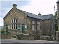
Loxley Methodist Chapel
An inscribed stone reads "Loxley Wesleyan Methodist Chapel 1885".
Image: © Graham Hogg
Taken: 23 Aug 2011
0.05 miles
4
Loxley Methodist Church, Loxley Road, Loxley, Sheffield - 2
Image: © Terry Robinson
Taken: 29 Oct 2008
0.06 miles
5
Loxley Methodist Church, Loxley Road, Loxley, Sheffield - 1
Image: © Terry Robinson
Taken: 29 Oct 2008
0.06 miles
6
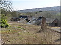
New Rolling Mills
Ruined industrial premises at Wisewood. Unlike most of the rolling mills in the Loxley Valley, this one would never have been water powered - it is too high up the side of the valley - and its name is token of its relatively late arrival on the scene, it would seem around 1900.
Image: © Alan Murray-Rust
Taken: 27 Mar 2012
0.06 miles
7
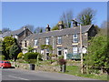
Cottages on Loxley Road
Possibly built for workers at the nearby Wisewood Brickworks, it would have stood without immediate neighbours for several decades before major housing development arrived in the inter-war period.
Image: © Alan Murray-Rust
Taken: 27 Mar 2012
0.07 miles
8
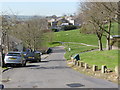
Studfield Hill near Studfield Rise
At this point the road still shows some of the characteristics of its early existence as a country lane. Much of the green area was formerly a ganister (fireclay) quarry.
Image: © Alan Murray-Rust
Taken: 27 Mar 2012
0.07 miles
9
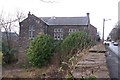
Loxley Ruins, Loxley Road, Loxley, Sheffield - 2
Image: © Terry Robinson
Taken: 29 Oct 2008
0.07 miles
10
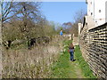
Footpath below Studfield Hill
The wall to the right marks the Sheffield City boundary.
Image: © Alan Murray-Rust
Taken: 27 Mar 2012
0.08 miles