IMAGES TAKEN NEAR TO
Oldfield Road, SHEFFIELD, S6 6DW
Introduction
This page details the photographs taken nearby to Oldfield Road, S6 6DW by members of the Geograph project.
The Geograph project started in 2005 with the aim of publishing, organising and preserving representative images for every square kilometre of Great Britain, Ireland and the Isle of Man.

There are currently over 7.5m images from over14,400 individuals and you can help contribute to the project by visiting https://www.geograph.org.uk
Image Map
Images are licensed for reuse under creativecommons.org/licenses/by-sa/2.0
Notes
- Clicking on the map will re-center to the selected point.
- The higher the marker number, the further away the image location is from the centre of the postcode.
Image Listing (9 Images Found)
Images are licensed for reuse under creativecommons.org/licenses/by-sa/2.0
Image
Details
Distance
1
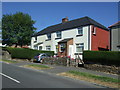
Houses on Oldfield Road, Stannington, Sheffield
Image: © JThomas
Taken: 30 Jun 2018
0.08 miles
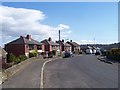
3
Hall Park Hill, Stannington
Maisonettes on Hall Park Hill. Below is mixed housing on Liberty Drive, Liberty Hill and Liberty Road.
Image: © Dave Hitchborne
Taken: 26 Aug 2008
0.17 miles
4
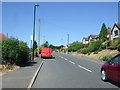
Oldfield Road, Stannington, Sheffield
Looking west.
Image: © JThomas
Taken: 30 Jun 2018
0.17 miles
6

Bus loading at Hall Park Head
Passengers board a 12 to Sheffield city centre at Hall Park Head terminus. Some of the interestingly designed housing that slopes in sympathy with the hillside on which it is built is visible on the right.
Image: © Richard Vince
Taken: 24 Apr 2012
0.22 miles
7

Hall Park Head bus terminus
Not a turning circle as such, the terminus at Hall Park Head is simply a huge patch of tarmac that, due to the hilly topography of the area, proved impossible to get into a photo in its entirety. The housing on the right (behind the willow tree) is built on a hillside, while the ground drops sharply to the photographer's left.
Image: © Richard Vince
Taken: 24 Apr 2012
0.22 miles
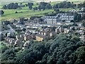
9

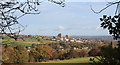
Stannington and Liberty Hill
The view from Stannington View Rd looking out over Stannington, Liberty Hill with the Loxley Valley in the distance. It was down this valley that the flood-water surged when the Dale Dyke dam burst on 11 March 1864 causing Britain's worst ever peace-time disaster in terms of fatalities. The dam just visible in the valley is Damflask.
Image: © Martin Speck
Taken: 6 Oct 2008
0.22 miles