IMAGES TAKEN NEAR TO
High Matlock Road, SHEFFIELD, S6 6AS
Introduction
This page details the photographs taken nearby to High Matlock Road, S6 6AS by members of the Geograph project.
The Geograph project started in 2005 with the aim of publishing, organising and preserving representative images for every square kilometre of Great Britain, Ireland and the Isle of Man.

There are currently over 7.5m images from over14,400 individuals and you can help contribute to the project by visiting https://www.geograph.org.uk
Image Map
Images are licensed for reuse under creativecommons.org/licenses/by-sa/2.0
Notes
- Clicking on the map will re-center to the selected point.
- The higher the marker number, the further away the image location is from the centre of the postcode.
Image Listing (8 Images Found)
Images are licensed for reuse under creativecommons.org/licenses/by-sa/2.0
Image
Details
Distance
1
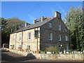
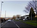
Chalet, Myers Grove Lane, Stannington, Sheffield
An interesting property on this suburban road ... sort of links two different phases of building.
Image: © Terry Robinson
Taken: 29 Oct 2008
0.13 miles
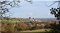
3

Stannington and Liberty Hill
The view from Stannington View Rd looking out over Stannington, Liberty Hill with the Loxley Valley in the distance. It was down this valley that the flood-water surged when the Dale Dyke dam burst on 11 March 1864 causing Britain's worst ever peace-time disaster in terms of fatalities. The dam just visible in the valley is Damflask.
Image: © Martin Speck
Taken: 6 Oct 2008
0.20 miles
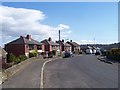
5
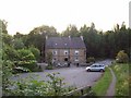
The Robin Hood Public House, Little Matlock
Characterful 19th Century inn viewed here on a warm and sunny evening in June 2011. Sadly the pub announced its impending closure just days after this picture was taken.
Image: © Jonathan Clitheroe
Taken: 2 Jun 2011
0.23 miles
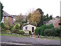
6
Woodland Cottage Farm, from Greaves Lane, Stannington, Sheffield - 1
Image: © Terry Robinson
Taken: 29 Oct 2008
0.23 miles