IMAGES TAKEN NEAR TO
Carr, ROTHERHAM, S66 8PR
Introduction
This page details the photographs taken nearby to Carr, S66 8PR by members of the Geograph project.
The Geograph project started in 2005 with the aim of publishing, organising and preserving representative images for every square kilometre of Great Britain, Ireland and the Isle of Man.

There are currently over 7.5m images from over14,400 individuals and you can help contribute to the project by visiting https://www.geograph.org.uk
Image Map
Images are licensed for reuse under creativecommons.org/licenses/by-sa/2.0
Notes
- Clicking on the map will re-center to the selected point.
- The higher the marker number, the further away the image location is from the centre of the postcode.
Image Listing (12 Images Found)
Images are licensed for reuse under creativecommons.org/licenses/by-sa/2.0
Image
Details
Distance
1
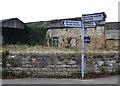
Signpost and old farm building in Carr
Image: © Neil Theasby
Taken: 16 Nov 2012
0.09 miles
3
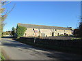
Outbuilding by Ramper Road in Carr
Image: © Jonathan Clitheroe
Taken: 13 Mar 2013
0.13 miles
5
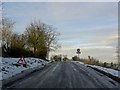
Arr
The sign says Arr but it means Carr on an icy morning.
Image: © Steve Fareham
Taken: 13 Feb 2009
0.17 miles
6
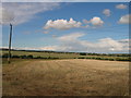
Beacon Hill
Bagged the trig, field and opposite field and field corner scrub is probably the highest point seen on a late November sunny afternoon with Martin Richardson. This completed our set of 5 Rotherham TUMPs.
Name: Beacon Hill
Hill number: 16809
Height: 151m / 495ft
Parent (Ma/M): 2807 Kinder Scout
Section: 37: The River Tees to The Wash
County/UA: Rotherham (UA)
Class: Tump (100-199m)
Grid ref: SK511899 (est)
Drop: 53m
Col: 98m SK484832
Image: © Rude Health
Taken: 22 Nov 2014
0.19 miles
7
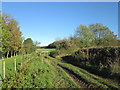
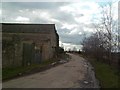
Path to Hooton Levitt leaves Tunwell Road
Tunwell Road turns sharply to the right here; though the gate is a footpath to Hooton Levitt.
Image: © John Slater
Taken: 4 Nov 2013
0.20 miles
8
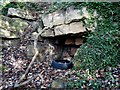
Sealed coal mine working in The Terrace
Image: © Neil Theasby
Taken: 30 Oct 2013
0.21 miles
9

Bee on ripe hawthorn berries, Tunwell Road, Carr
Image: © Neil Theasby
Taken: 16 Nov 2012
0.23 miles