IMAGES TAKEN NEAR TO
Redwood Drive, ROTHERHAM, S66 8DL
Introduction
This page details the photographs taken nearby to Redwood Drive, S66 8DL by members of the Geograph project.
The Geograph project started in 2005 with the aim of publishing, organising and preserving representative images for every square kilometre of Great Britain, Ireland and the Isle of Man.

There are currently over 7.5m images from over14,400 individuals and you can help contribute to the project by visiting https://www.geograph.org.uk
Image Map
Images are licensed for reuse under creativecommons.org/licenses/by-sa/2.0
Notes
- Clicking on the map will re-center to the selected point.
- The higher the marker number, the further away the image location is from the centre of the postcode.
Image Listing (7 Images Found)
Images are licensed for reuse under creativecommons.org/licenses/by-sa/2.0
Image
Details
Distance
2
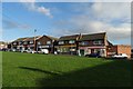
Addison Road
View down the hill at Maltby
Image: © Richard Croft
Taken: 28 Jul 2006
0.18 miles
3
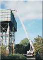
Surveying the water tower
A 'Bronto skylift' (allegedly the biggest hydraulic platform in the UK) being used to survey the water tower in Lilley Hall Lane. The tower was leaning dangerously due to mining subsidence and was subsequently demolished.
Image: © Stephen Craven
Taken: 18 Oct 1995
0.19 miles
5
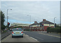
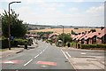
Hooton Levitt traffic lights
Junction of Addison Road and A631
Image: © John Firth
Taken: 13 Jul 2011
0.24 miles
7

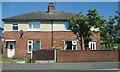
WRCC Milestone
One of 615 milestones erected for the West Riding County Council in 1893/94.
Repainted by the householder in May 2020.
Image: © Chris Minto
Taken: 9 May 2020
0.25 miles