IMAGES TAKEN NEAR TO
Common Lane, ROTHERHAM, S66 7RX
Introduction
This page details the photographs taken nearby to Common Lane, S66 7RX by members of the Geograph project.
The Geograph project started in 2005 with the aim of publishing, organising and preserving representative images for every square kilometre of Great Britain, Ireland and the Isle of Man.

There are currently over 7.5m images from over14,400 individuals and you can help contribute to the project by visiting https://www.geograph.org.uk
Image Map
Images are licensed for reuse under creativecommons.org/licenses/by-sa/2.0
Notes
- Clicking on the map will re-center to the selected point.
- The higher the marker number, the further away the image location is from the centre of the postcode.
Image Listing (19 Images Found)
Images are licensed for reuse under creativecommons.org/licenses/by-sa/2.0
Image
Details
Distance
1
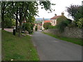
Common Lane in Clifton
This small village occupies an elevated position with excellent views to the north toward Conisbrough and the Don Valley.
Image: © Jonathan Clitheroe
Taken: 11 Nov 2016
0.03 miles
2
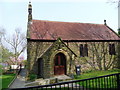
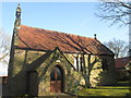
Clifton church.
A very small church.
Image: © steven ruffles
Taken: 22 Apr 2011
0.04 miles

4
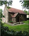
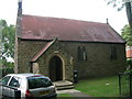
Clifton Mission Church, Clifton
A Church of England facility serving this small village - with a population of less than four hundred.
Image: © Neil Theasby
Taken: 25 Jun 2014
0.04 miles
6
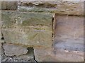
Ordnance Survey Cut Mark
This OS cut mark can be found on the SW face of the church. It marks a point 123.1026m above mean sea level.
Image: © Adrian Dust
Taken: 23 May 2016
0.05 miles

9
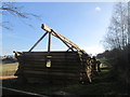
Log cabin under construction at Clifton
Image: © John Slater
Taken: 23 Mar 2015
0.06 miles