IMAGES TAKEN NEAR TO
Ashton Lane, ROTHERHAM, S66 7RL
Introduction
This page details the photographs taken nearby to Ashton Lane, S66 7RL by members of the Geograph project.
The Geograph project started in 2005 with the aim of publishing, organising and preserving representative images for every square kilometre of Great Britain, Ireland and the Isle of Man.

There are currently over 7.5m images from over14,400 individuals and you can help contribute to the project by visiting https://www.geograph.org.uk
Image Map
Images are licensed for reuse under creativecommons.org/licenses/by-sa/2.0
Notes
- Clicking on the map will re-center to the selected point.
- The higher the marker number, the further away the image location is from the centre of the postcode.
Image Listing (6 Images Found)
Images are licensed for reuse under creativecommons.org/licenses/by-sa/2.0
Image
Details
Distance
1
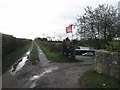
Entrance to the shooting range beside Hoyle Croft Lane
Image: © John Slater
Taken: 12 Nov 2013
0.10 miles
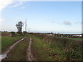
2
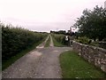
Hoyle Croft Lane near Braithwell
The red flags indicate the presence of a rifle range to the right of the lane.
Image: © Jonathan Clitheroe
Taken: 19 Jun 2016
0.11 miles
3
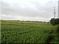
Crop Field and Mast off Hoyle Croft Lane
Poppies intermingling with a field of wheat, pictured from the northern edge of the square.
Image: © Jonathan Clitheroe
Taken: 19 Jun 2016
0.19 miles
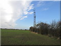
6
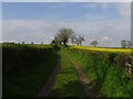
Hoyle croft lane.
Leaving Braithwell along the Danum trail.
Image: © steven ruffles
Taken: 24 Apr 2012
0.21 miles