IMAGES TAKEN NEAR TO
Long Leys Lane, ROTHERHAM, S66 7BS
Introduction
This page details the photographs taken nearby to Long Leys Lane, S66 7BS by members of the Geograph project.
The Geograph project started in 2005 with the aim of publishing, organising and preserving representative images for every square kilometre of Great Britain, Ireland and the Isle of Man.

There are currently over 7.5m images from over14,400 individuals and you can help contribute to the project by visiting https://www.geograph.org.uk
Image Map
Images are licensed for reuse under creativecommons.org/licenses/by-sa/2.0
Notes
- Clicking on the map will re-center to the selected point.
- The higher the marker number, the further away the image location is from the centre of the postcode.
Image Listing (11 Images Found)
Images are licensed for reuse under creativecommons.org/licenses/by-sa/2.0
Image
Details
Distance
1
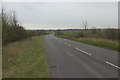
Long Leys Lane approaching Braithwell
Image: © Mark Anderson
Taken: 23 Mar 2016
0.02 miles

5
Conisbrough : Roadside
Roadside along the M18.
Image: © Lewis Clarke
Taken: 20 Sep 2020
0.08 miles
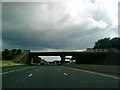
6
The M18 seen from Long Leys Lane bridge
Image: © Neil Theasby
Taken: 19 Sep 2017
0.08 miles
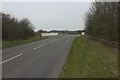
7
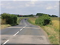
Short Hedges and Bends
This road, the B6376, looks virtually straight on a map but when compressed its curves come out. At the top of the hill the M18 runs beneath the road.
Image: © Michael Patterson
Taken: 7 Jul 2006
0.10 miles
8

Whoops
Leaning sign to Clifton with the M18 motorway in the background.
Image: © Steve Fareham
Taken: 25 Oct 2007
0.15 miles
9

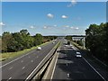
Conisbrough : M18 Motorway
Looking along the M18 Motorway.
Image: © Lewis Clarke
Taken: 20 Sep 2020
0.17 miles
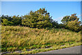
10

Conisbrough : Grassy Field
A field seen off the M18 Motorway.
Image: © Lewis Clarke
Taken: 20 Sep 2020
0.20 miles