IMAGES TAKEN NEAR TO
Waterside Drive, ROTHERHAM, S66 3ZW
Introduction
This page details the photographs taken nearby to Waterside Drive, S66 3ZW by members of the Geograph project.
The Geograph project started in 2005 with the aim of publishing, organising and preserving representative images for every square kilometre of Great Britain, Ireland and the Isle of Man.

There are currently over 7.5m images from over14,400 individuals and you can help contribute to the project by visiting https://www.geograph.org.uk
Image Map
Images are licensed for reuse under creativecommons.org/licenses/by-sa/2.0
Notes
- Clicking on the map will re-center to the selected point.
- The higher the marker number, the further away the image location is from the centre of the postcode.
Image Listing (11 Images Found)
Images are licensed for reuse under creativecommons.org/licenses/by-sa/2.0
Image
Details
Distance
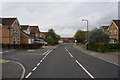
1
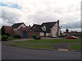
The Woodman Public House
Modern pub situated on Woodlaithes Road.
Image: © Jonathan Clitheroe
Taken: 6 Aug 2013
0.06 miles
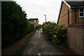
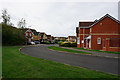
2
Terraced houses on Holling's Lane near Ravenfield Common
Image: © Neil Theasby
Taken: 25 Jun 2013
0.17 miles
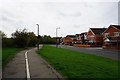
6
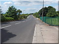
Holling's Lane
Photograph taken from the entrance to Silverwood electricity sub-station
Image: © Neil Theasby
Taken: 25 Jun 2013
0.24 miles
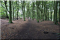
8
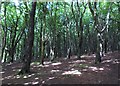
Silver Wood - beech wood north of Sunnyside
Image: © Neil Theasby
Taken: 25 Jun 2013
0.24 miles