IMAGES TAKEN NEAR TO
Chestnut Court, ROTHERHAM, S65 4RA
Introduction
This page details the photographs taken nearby to Chestnut Court, S65 4RA by members of the Geograph project.
The Geograph project started in 2005 with the aim of publishing, organising and preserving representative images for every square kilometre of Great Britain, Ireland and the Isle of Man.

There are currently over 7.5m images from over14,400 individuals and you can help contribute to the project by visiting https://www.geograph.org.uk
Image Map
Images are licensed for reuse under creativecommons.org/licenses/by-sa/2.0
Notes
- Clicking on the map will re-center to the selected point.
- The higher the marker number, the further away the image location is from the centre of the postcode.
Image Listing (20 Images Found)
Images are licensed for reuse under creativecommons.org/licenses/by-sa/2.0
Image
Details
Distance
1
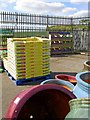
Foster's garden centre Thrybergh #2
A long established garden centre on the western edge of Rotherham.
Image: © Steve Fareham
Taken: 15 May 2010
0.02 miles
2
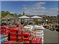
Foster's garden centre Thrybergh
A long established centre.
Image: © Steve Fareham
Taken: 15 May 2010
0.02 miles
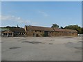
4
Antique and Garden centre car park, Thrybergh
Image: © Glyn Drury
Taken: 28 Jul 2009
0.04 miles
8
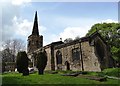
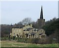
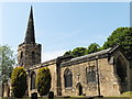
St Leonard's Church, Thrybergh
Parts of this ancient church date back to pre-Norman times. It is currently undergoing some vital restorative building work.
Image: © Neil Theasby
Taken: 24 Apr 2014
0.11 miles
10
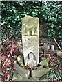
Old boundary cross - Thrybergh, St Leonard's
This curious ancient cross once stood on East Hill, Thrybergh. The front carving shows amongst other things a man with a book - this is thought to have been a 12th century addition to what was originally a saxon boundary stone. It was moved from its original site to the churchyard at Thrybergh in 1947.
For more information on this cross go to http://johndoxey.100freemb.com/st_leonard_reresby.htm
Image: © Neil Theasby
Taken: 24 Apr 2014
0.12 miles