IMAGES TAKEN NEAR TO
Dovecote Lane, ROTHERHAM, S65 4NW
Introduction
This page details the photographs taken nearby to Dovecote Lane, S65 4NW by members of the Geograph project.
The Geograph project started in 2005 with the aim of publishing, organising and preserving representative images for every square kilometre of Great Britain, Ireland and the Isle of Man.

There are currently over 7.5m images from over14,400 individuals and you can help contribute to the project by visiting https://www.geograph.org.uk
Image Map
Images are licensed for reuse under creativecommons.org/licenses/by-sa/2.0
Notes
- Clicking on the map will re-center to the selected point.
- The higher the marker number, the further away the image location is from the centre of the postcode.
Image Listing (30 Images Found)
Images are licensed for reuse under creativecommons.org/licenses/by-sa/2.0
Image
Details
Distance
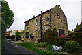
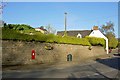
1
Row of Cottages in Ravenfield
Coursed sandstone dwellings on Main Street in the centre of the village.
Image: © Jonathan Clitheroe
Taken: 6 Aug 2013
0.04 miles
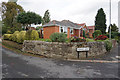
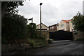
8
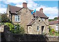
House on Church Lane, Ravenfield
The Yorkshire flag flies proudly in front of this stone property.
Image: © Neil Theasby
Taken: 25 Jun 2013
0.09 miles