IMAGES TAKEN NEAR TO
Deer Leap Drive, ROTHERHAM, S65 4DU
Introduction
This page details the photographs taken nearby to Deer Leap Drive, S65 4DU by members of the Geograph project.
The Geograph project started in 2005 with the aim of publishing, organising and preserving representative images for every square kilometre of Great Britain, Ireland and the Isle of Man.

There are currently over 7.5m images from over14,400 individuals and you can help contribute to the project by visiting https://www.geograph.org.uk
Image Map
Images are licensed for reuse under creativecommons.org/licenses/by-sa/2.0
Notes
- Clicking on the map will re-center to the selected point.
- The higher the marker number, the further away the image location is from the centre of the postcode.
Image Listing (4 Images Found)
Images are licensed for reuse under creativecommons.org/licenses/by-sa/2.0
Image
Details
Distance
1
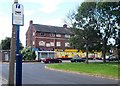
View of a shopping parade in Thrybergh
The bus stop sign refers to Deer Park Road and Gerard Avenue.
Image: © Neil Theasby
Taken: 25 Jun 2013
0.13 miles
2
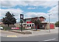
"The Reresby Arms" public house in Thrybergh
"Reresby" is the correct spelling and not "Rearsby" on any other variation. The regulars are most particular about spelling.
Image: © Neil Theasby
Taken: 25 Jun 2013
0.20 miles
3
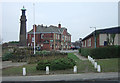
Thrybergh - War Memorial and The Fullerton
The pub is an imposing building in semi-classical style and clearly dates from the expansion of Thrybergh as residential area for local steelworkers and miners.
Image: © Alan Murray-Rust
Taken: 16 Dec 2007
0.24 miles
4
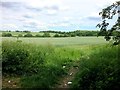
Farmland on the Outskirts of Thrybergh
Most of the landscape on the left of this photo is located to the north in SK4795.
Image: © Jonathan Clitheroe
Taken: 3 Jun 2017
0.24 miles