IMAGES TAKEN NEAR TO
Hargrave Place, ROTHERHAM, S65 4BY
Introduction
This page details the photographs taken nearby to Hargrave Place, S65 4BY by members of the Geograph project.
The Geograph project started in 2005 with the aim of publishing, organising and preserving representative images for every square kilometre of Great Britain, Ireland and the Isle of Man.

There are currently over 7.5m images from over14,400 individuals and you can help contribute to the project by visiting https://www.geograph.org.uk
Image Map
Images are licensed for reuse under creativecommons.org/licenses/by-sa/2.0
Notes
- Clicking on the map will re-center to the selected point.
- The higher the marker number, the further away the image location is from the centre of the postcode.
Image Listing (5 Images Found)
Images are licensed for reuse under creativecommons.org/licenses/by-sa/2.0
Image
Details
Distance
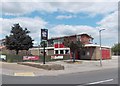
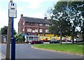
2
The Royal Oak is closed
On Hollings Lane.
Image: © Steve Fareham
Taken: 23 Apr 2009
0.11 miles
3
"The Reresby Arms" public house in Thrybergh
"Reresby" is the correct spelling and not "Rearsby" on any other variation. The regulars are most particular about spelling.
Image: © Neil Theasby
Taken: 25 Jun 2013
0.12 miles
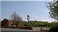
4
View of a shopping parade in Thrybergh
The bus stop sign refers to Deer Park Road and Gerard Avenue.
Image: © Neil Theasby
Taken: 25 Jun 2013
0.21 miles