IMAGES TAKEN NEAR TO
Haywood Close, ROTHERHAM, S65 3RL
Introduction
This page details the photographs taken nearby to Haywood Close, S65 3RL by members of the Geograph project.
The Geograph project started in 2005 with the aim of publishing, organising and preserving representative images for every square kilometre of Great Britain, Ireland and the Isle of Man.

There are currently over 7.5m images from over14,400 individuals and you can help contribute to the project by visiting https://www.geograph.org.uk
Image Map
Images are licensed for reuse under creativecommons.org/licenses/by-sa/2.0
Notes
- Clicking on the map will re-center to the selected point.
- The higher the marker number, the further away the image location is from the centre of the postcode.
Image Listing (4 Images Found)
Images are licensed for reuse under creativecommons.org/licenses/by-sa/2.0
Image
Details
Distance
2
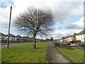
Footpath through urban green space
To the east of Herringthorpe Valley Road
Image: © Graham Hogg
Taken: 13 Mar 2018
0.22 miles
3
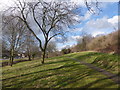
East Herringthorpe estate, Rotherham
Same wet day as Dalton Image, same area, but this time higher up the estate with the Corus Aldwarke steelworks in the distance, looking north.
Image: © David Morris
Taken: 20 May 2006
0.22 miles
4
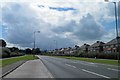
The A6123 Herringthorpe Valley Road, Rotherham
Image: © Steve Fareham
Taken: 29 Jul 2012
0.22 miles