IMAGES TAKEN NEAR TO
The Brow, ROTHERHAM, S65 3HP
Introduction
This page details the photographs taken nearby to The Brow, S65 3HP by members of the Geograph project.
The Geograph project started in 2005 with the aim of publishing, organising and preserving representative images for every square kilometre of Great Britain, Ireland and the Isle of Man.

There are currently over 7.5m images from over14,400 individuals and you can help contribute to the project by visiting https://www.geograph.org.uk
Image Map
Images are licensed for reuse under creativecommons.org/licenses/by-sa/2.0
Notes
- Clicking on the map will re-center to the selected point.
- The higher the marker number, the further away the image location is from the centre of the postcode.
Image Listing (7 Images Found)
Images are licensed for reuse under creativecommons.org/licenses/by-sa/2.0
Image
Details
Distance
1
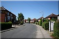
Brecks Crescent
Residential suburban Rotherham
Image: © Richard Croft
Taken: 24 Jul 2006
0.16 miles
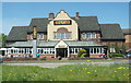
2
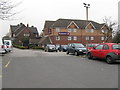
The Brecks and Premier Inn
Hotel and Beefeeater Restaurant on the A631 at Rotherham.
Image: © M J Richardson
Taken: 3 Mar 2011
0.17 miles
4
Bawtry Road, Brecks
Otherwise known as the A631, taken from near Hollin Hill Farm
Image: © Richard Croft
Taken: 24 Jul 2006
0.17 miles
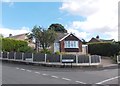
6
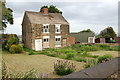
Binder's Farm, The Brecks, Rotherham
Binder's Farm, now deserted awaiting demolition.
Image: © John Charlton
Taken: 29 May 2011
0.20 miles
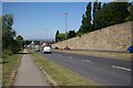
7
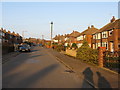
Sheep Cote Road
Suburban housing on the SE outskirts of Rotherham.
Image: © M J Richardson
Taken: 2 Mar 2011
0.24 miles