IMAGES TAKEN NEAR TO
Ash Close, ROTHERHAM, S65 3DX
Introduction
This page details the photographs taken nearby to Ash Close, S65 3DX by members of the Geograph project.
The Geograph project started in 2005 with the aim of publishing, organising and preserving representative images for every square kilometre of Great Britain, Ireland and the Isle of Man.

There are currently over 7.5m images from over14,400 individuals and you can help contribute to the project by visiting https://www.geograph.org.uk
Image Map
Images are licensed for reuse under creativecommons.org/licenses/by-sa/2.0
Notes
- Clicking on the map will re-center to the selected point.
- The higher the marker number, the further away the image location is from the centre of the postcode.
Image Listing (11 Images Found)
Images are licensed for reuse under creativecommons.org/licenses/by-sa/2.0
Image
Details
Distance
1
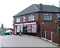
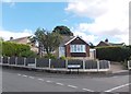
Post office in east Rotherham
On the corner of Brecks Lane and East Bawtry Road
Image: © Neil Theasby
Taken: 16 Aug 2013
0.07 miles
3
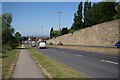
Bawtry Road, Brecks
Otherwise known as the A631, taken from near Hollin Hill Farm
Image: © Richard Croft
Taken: 24 Jul 2006
0.13 miles
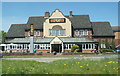
4
The Brecks and Premier Inn
Hotel and Beefeeater Restaurant on the A631 at Rotherham.
Image: © M J Richardson
Taken: 3 Mar 2011
0.13 miles
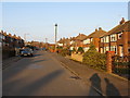
6
Sheep Cote Road
Looking north-east towards the Brecks and Bawtry Road.
Image: © M J Richardson
Taken: 2 Mar 2011
0.20 miles
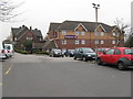
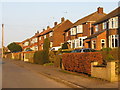
7
Sheep Cote Road
Suburban housing on the SE outskirts of Rotherham.
Image: © M J Richardson
Taken: 2 Mar 2011
0.20 miles
8
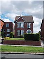
House with half a hedge in Rotherham
There are numerous attractive house like this one on Wickersley Road, Rotherham.
Image: © Neil Theasby
Taken: 16 Aug 2013
0.20 miles
9

Old Milestone, on the A6021, Wickersley Road
Between A6123 and Brecks A631. Located on the South side of road, in pavement, backing onto brick wall of No. 214. Metal plate attached to stone post, Brayshaw & Booth casting design, 19th century.
Inscription reads: ROTHERHAM / 2 MILES // BARNBY / MOOR / 15 MILES / BAWTRY / 12¼ MILES / TICKHILL / 9 MILES // ROTHERHAM & BARNBY MOOR / ROAD / WHISTON // BRAYSHAW & BOOTH / MAKERS / LIVERSEDGE
Grade II listed by Historic England. see https://historicengland.org.uk/listing/the-list/list-entry/1132726
Milestone Society National ID: YS_RMBM02
Image: © Christine Minto
Taken: 3 Jan 2006
0.25 miles
10
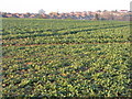
Oilseed rape at Whiston
Looking across the field to the back of the houses on Sheep Cote Road
Image: © M J Richardson
Taken: 2 Mar 2011
0.25 miles