IMAGES TAKEN NEAR TO
Herringthorpe Valley Road, ROTHERHAM, S65 3AH
Introduction
This page details the photographs taken nearby to Herringthorpe Valley Road, S65 3AH by members of the Geograph project.
The Geograph project started in 2005 with the aim of publishing, organising and preserving representative images for every square kilometre of Great Britain, Ireland and the Isle of Man.

There are currently over 7.5m images from over14,400 individuals and you can help contribute to the project by visiting https://www.geograph.org.uk
Image Map
Images are licensed for reuse under creativecommons.org/licenses/by-sa/2.0
Notes
- Clicking on the map will re-center to the selected point.
- The higher the marker number, the further away the image location is from the centre of the postcode.
Image Listing (4 Images Found)
Images are licensed for reuse under creativecommons.org/licenses/by-sa/2.0
Image
Details
Distance
2
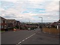
Junction of Leedham Road and Great Bank Road
The suburb of Brecks to the east of Rotherham town centre. The Wentworth Estate can also be seen here, bathed in sunshine towards the horizon.
Image: © Jonathan Clitheroe
Taken: 6 Aug 2013
0.22 miles
4
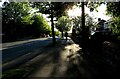
Wickersley Road, Broom
Wickersley Road between the Middle Lane junction and Stag Roundabout. View towards the Stag Roundabout
Image: © Ryk Rak
Taken: 16 May 2019
0.24 miles