IMAGES TAKEN NEAR TO
Dene Crescent, ROTHERHAM, S65 2UP
Introduction
This page details the photographs taken nearby to Dene Crescent, S65 2UP by members of the Geograph project.
The Geograph project started in 2005 with the aim of publishing, organising and preserving representative images for every square kilometre of Great Britain, Ireland and the Isle of Man.

There are currently over 7.5m images from over14,400 individuals and you can help contribute to the project by visiting https://www.geograph.org.uk
Image Map
Images are licensed for reuse under creativecommons.org/licenses/by-sa/2.0
Notes
- Clicking on the map will re-center to the selected point.
- The higher the marker number, the further away the image location is from the centre of the postcode.
Image Listing (6 Images Found)
Images are licensed for reuse under creativecommons.org/licenses/by-sa/2.0
Image
Details
Distance
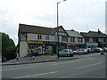
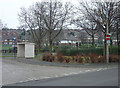
3
Unusual combination
Mowbray gardens library and swimming pool.
Image: © Steve Fareham
Taken: 6 Nov 2007
0.23 miles
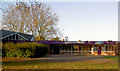
4
Mowbray Gardens Library, Herringthorpe
The purple band is certainly eye-catching, if not to everyone's taste. The lower building in the background with the purple water tank is a swimming pool.
Image: © Alan Murray-Rust
Taken: 16 Dec 2007
0.24 miles
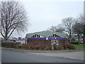
5
Mowbray Gardens, 42 years on
The same view as Image The road layout has been changed to allow for a two-way bus road instead of the old turning circle. Trees have matured and the houses have received a different paint scheme
Image: © Alan Murray-Rust
Taken: 16 Dec 2007
0.25 miles
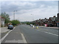
6
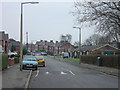
Mowbray Street, Herringthorpe
A typical suburban road on a council-built estate, now provided with the almost inevitable road humps.
Image: © Alan Murray-Rust
Taken: 16 Dec 2007
0.25 miles