IMAGES TAKEN NEAR TO
Oak Meadows, ROTHERHAM, S65 2TB
Introduction
This page details the photographs taken nearby to Oak Meadows, S65 2TB by members of the Geograph project.
The Geograph project started in 2005 with the aim of publishing, organising and preserving representative images for every square kilometre of Great Britain, Ireland and the Isle of Man.

There are currently over 7.5m images from over14,400 individuals and you can help contribute to the project by visiting https://www.geograph.org.uk
Image Map
Images are licensed for reuse under creativecommons.org/licenses/by-sa/2.0
Notes
- Clicking on the map will re-center to the selected point.
- The higher the marker number, the further away the image location is from the centre of the postcode.
Image Listing (12 Images Found)
Images are licensed for reuse under creativecommons.org/licenses/by-sa/2.0
Image
Details
Distance
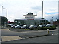
2
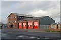
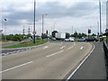
Rotherham fire station
Rotherham fire station, Fitzwilliam Road, Eastwood, Rotherham, South Yorkshire
Image: © Kevin Hale
Taken: 5 Dec 2009
0.13 miles
4
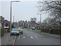
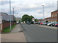
Mowbray Street, Herringthorpe
A typical suburban road on a council-built estate, now provided with the almost inevitable road humps.
Image: © Alan Murray-Rust
Taken: 16 Dec 2007
0.14 miles
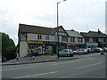
9
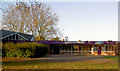
Unusual combination
Mowbray gardens library and swimming pool.
Image: © Steve Fareham
Taken: 6 Nov 2007
0.23 miles