IMAGES TAKEN NEAR TO
Fitzwilliam Road, ROTHERHAM, S65 1SL
Introduction
This page details the photographs taken nearby to Fitzwilliam Road, S65 1SL by members of the Geograph project.
The Geograph project started in 2005 with the aim of publishing, organising and preserving representative images for every square kilometre of Great Britain, Ireland and the Isle of Man.

There are currently over 7.5m images from over14,400 individuals and you can help contribute to the project by visiting https://www.geograph.org.uk
Image Map
Images are licensed for reuse under creativecommons.org/licenses/by-sa/2.0
Notes
- Clicking on the map will re-center to the selected point.
- The higher the marker number, the further away the image location is from the centre of the postcode.
Image Listing (10 Images Found)
Images are licensed for reuse under creativecommons.org/licenses/by-sa/2.0
Image
Details
Distance
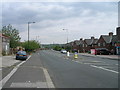
2
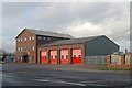
Rotherham fire station
Rotherham fire station, Fitzwilliam Road, Eastwood, Rotherham, South Yorkshire
Image: © Kevin Hale
Taken: 5 Dec 2009
0.16 miles
7
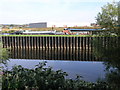
Iron River Bank
The River Don viewed from Eastwood Trading Estate.
Image: © Michael Patterson
Taken: 15 Sep 2006
0.22 miles
10
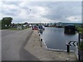
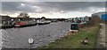
End of the Rotherham Cut
The Rotherham Cut ends here. You can see the lock gates (left) taking canal traffic onto a navigable section of the River Don.
Image: © Martin Speck
Taken: 18 May 2008
0.25 miles