IMAGES TAKEN NEAR TO
St. Anns Road, ROTHERHAM, S65 1SA
Introduction
This page details the photographs taken nearby to St. Anns Road, S65 1SA by members of the Geograph project.
The Geograph project started in 2005 with the aim of publishing, organising and preserving representative images for every square kilometre of Great Britain, Ireland and the Isle of Man.

There are currently over 7.5m images from over14,400 individuals and you can help contribute to the project by visiting https://www.geograph.org.uk
Image Map
Images are licensed for reuse under creativecommons.org/licenses/by-sa/2.0
Notes
- Clicking on the map will re-center to the selected point.
- The higher the marker number, the further away the image location is from the centre of the postcode.
Image Listing (30 Images Found)
Images are licensed for reuse under creativecommons.org/licenses/by-sa/2.0
Image
Details
Distance
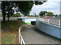
3
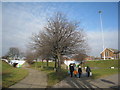
Within the roundabout
The traffic swirls all around but in the middle of this large roundabout calm prevails.
Image: © Jonathan Thacker
Taken: 29 Jan 2011
0.07 miles
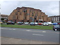
4
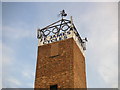
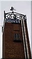
Cycling Weathervane
This weathervane takes the form of a cyclist, which is very apt as it is on top of a cycle shop. The building is an ex-fire station, which explains the tower.
Image: © Christopher Thomas
Taken: 23 Sep 2005
0.09 miles
7
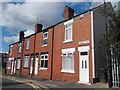
Terraced houses on Rawson Road, Rotherham
Image: © Neil Theasby
Taken: 16 Aug 2013
0.13 miles
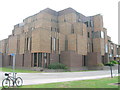
9
J E James cycles
The Old fire station, Erskine Road, Eastwood.
Image: © Steve Fareham
Taken: 22 Mar 2009
0.14 miles
10
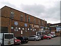
J E James cycles, Erskine Road, Eastwood, Rotherham
In a former fire station.
Image: © Steve Fareham
Taken: 22 Mar 2009
0.14 miles