IMAGES TAKEN NEAR TO
Ridge Road, ROTHERHAM, S65 1QD
Introduction
This page details the photographs taken nearby to Ridge Road, S65 1QD by members of the Geograph project.
The Geograph project started in 2005 with the aim of publishing, organising and preserving representative images for every square kilometre of Great Britain, Ireland and the Isle of Man.

There are currently over 7.5m images from over14,400 individuals and you can help contribute to the project by visiting https://www.geograph.org.uk
Image Map
Images are licensed for reuse under creativecommons.org/licenses/by-sa/2.0
Notes
- Clicking on the map will re-center to the selected point.
- The higher the marker number, the further away the image location is from the centre of the postcode.
Image Listing (33 Images Found)
Images are licensed for reuse under creativecommons.org/licenses/by-sa/2.0
Image
Details
Distance
1
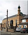
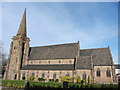
Mosque in Ridge Road, Rotherham
Markaz-ul-Uloom Al-Islamia
Image: © Chris Morgan
Taken: 12 Feb 2020
0.06 miles
4
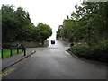
Clifton Park - Doncaster Road Entrance
Image: © Jonathan Clitheroe
Taken: 8 Aug 2016
0.10 miles
7
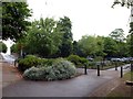
Rotherham - Clifton Park view of Cottenham Road
Image: © Alan Heardman
Taken: 9 Sep 2008
0.13 miles
8
Car park in the park
Small car park at Clifton Park
Image: © Graham Hogg
Taken: 15 Jun 2013
0.14 miles
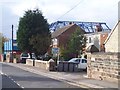
9
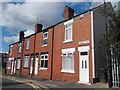
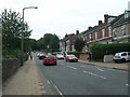
Terraced houses on Rawson Road, Rotherham
Image: © Neil Theasby
Taken: 16 Aug 2013
0.14 miles
10
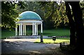
Clifton Park Bandstand
The bandstand is seldom used nowadays. However, during the annual (pre-covid days) Rotherham Show various musical performances take place on the bandstand over the two days of the Show and is well attended.
Image: © Ryk Rak
Taken: 2 Sep 2019
0.16 miles