IMAGES TAKEN NEAR TO
St. Anns Road, ROTHERHAM, S65 1PF
Introduction
This page details the photographs taken nearby to St. Anns Road, S65 1PF by members of the Geograph project.
The Geograph project started in 2005 with the aim of publishing, organising and preserving representative images for every square kilometre of Great Britain, Ireland and the Isle of Man.

There are currently over 7.5m images from over14,400 individuals and you can help contribute to the project by visiting https://www.geograph.org.uk
Image Map
Images are licensed for reuse under creativecommons.org/licenses/by-sa/2.0
Notes
- Clicking on the map will re-center to the selected point.
- The higher the marker number, the further away the image location is from the centre of the postcode.
Image Listing (46 Images Found)
Images are licensed for reuse under creativecommons.org/licenses/by-sa/2.0
Image
Details
Distance
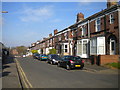
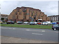
6
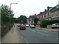
Carlisle Street, Rotherham
Off Wharncliffe Street, on the north eastern edge of the town centre.
Image: © Richard Vince
Taken: 30 Mar 2019
0.10 miles
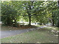
7
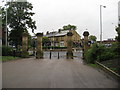
Rotherham - Leaving Clifton Park
Looking through the gateway towards the junction of Clifton Lane, Doncaster Road and Wharncliffe Street.
Image: © Alan Heardman
Taken: 9 Sep 2008
0.12 miles
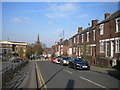
8
Wharncliffe Street, Rotherham
Looking down into the Don valley.
Image: © Richard Vince
Taken: 30 Mar 2019
0.12 miles
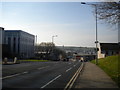
10
Clifton Park - Doncaster Road Entrance
Image: © Jonathan Clitheroe
Taken: 8 Aug 2016
0.12 miles