IMAGES TAKEN NEAR TO
Bowen Road, ROTHERHAM, S65 1LH
Introduction
This page details the photographs taken nearby to Bowen Road, S65 1LH by members of the Geograph project.
The Geograph project started in 2005 with the aim of publishing, organising and preserving representative images for every square kilometre of Great Britain, Ireland and the Isle of Man.

There are currently over 7.5m images from over14,400 individuals and you can help contribute to the project by visiting https://www.geograph.org.uk
Image Map
Images are licensed for reuse under creativecommons.org/licenses/by-sa/2.0
Notes
- Clicking on the map will re-center to the selected point.
- The higher the marker number, the further away the image location is from the centre of the postcode.
Image Listing (9 Images Found)
Images are licensed for reuse under creativecommons.org/licenses/by-sa/2.0
Image
Details
Distance
1
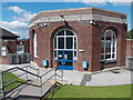
"The Place", Rotherham
Though the building had previous uses it is now a "children and young people's centre" operated by the NHS within the Clifton Partnership.
Image: © Neil Theasby
Taken: 16 Aug 2013
0.09 miles
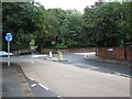
2
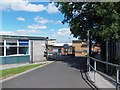
Entrance to Coleridge Primary School, Rotherham
Image: © Neil Theasby
Taken: 16 Aug 2013
0.14 miles
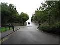
4
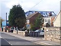
Rotherham - Middle Lane Junction with Doncaster Road
Image: © Alan Heardman
Taken: 9 Sep 2008
0.19 miles
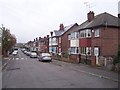
6
Rotherham - Clifton Park view of Cottenham Road
Image: © Alan Heardman
Taken: 9 Sep 2008
0.21 miles
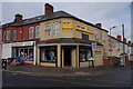
7
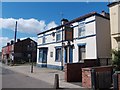
"The Donfield Tavern", Eldon Road, Rotherham
Another verse in the death of the back street boozer.
Image: © Neil Theasby
Taken: 16 Aug 2013
0.22 miles
8
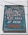
Flaking sign on the front of "The Donfield Tavern"
A sign of better, busier times remembered perhaps.
Image: © Neil Theasby
Taken: 16 Aug 2013
0.22 miles