IMAGES TAKEN NEAR TO
Cox Road, SHEFFIELD, S6 4SX
Introduction
This page details the photographs taken nearby to Cox Road, S6 4SX by members of the Geograph project.
The Geograph project started in 2005 with the aim of publishing, organising and preserving representative images for every square kilometre of Great Britain, Ireland and the Isle of Man.

There are currently over 7.5m images from over14,400 individuals and you can help contribute to the project by visiting https://www.geograph.org.uk
Image Map
Images are licensed for reuse under creativecommons.org/licenses/by-sa/2.0
Notes
- Clicking on the map will re-center to the selected point.
- The higher the marker number, the further away the image location is from the centre of the postcode.
Image Listing (24 Images Found)
Images are licensed for reuse under creativecommons.org/licenses/by-sa/2.0
Image
Details
Distance
1
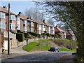
Loxley Road, Wisewood
These houses are on the site of the former Wisewood Brickworks.
Image: © Alan Murray-Rust
Taken: 27 Mar 2012
0.16 miles
2
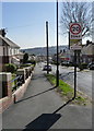
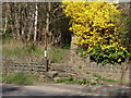
Studfield Road
The sign suggests that this is the edge of the Wisewood housing estate.
Image: © Alan Murray-Rust
Taken: 27 Mar 2012
0.16 miles
3

View from Loxley House, Loxley, Sheffield
This view, from the front gardens of Loxley House, is towards Sheffield City Centre. The 'under construction' St Paul's Tower is visible in the distance. Image Image
Image: © Terry Robinson
Taken: 11 Jan 2009
0.19 miles
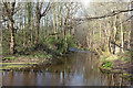
5
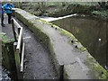
River Loxley at Wisewood
The substantial wall next to a weir protects the sluice gate feeding the millpond of the former Wisewood forge.
Image: © Rudi Winter
Taken: 5 Apr 2012
0.19 miles
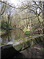
6
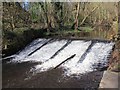
Massive masonry flanking a weir, Wisewood
The River Loxley flows over a weir. Below the camera and lower left is the intake from the river to feed the former mill pond of the former Wisewood Forge and Rolling Mill.
Image: © Robin Stott
Taken: 5 Apr 2012
0.19 miles
7
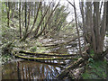
Fallen saplings, head of mill pond, Wisewood
Self-sown sycamores have fallen over in soft ground.
Image: © Robin Stott
Taken: 5 Apr 2012
0.20 miles
8
Weir on River Loxley by Wisewood Forge
This is the River Loxley as it flows past the Wisewood Forge mill pond. Taken during the Geograph Conference 2012 second guided walk.
Image: © David P Howard
Taken: 5 Apr 2012
0.20 miles
9
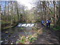
Weir at Wisewood mill pond
The weir is in the river Loxley. To the right of the footpath, just next to the trees, lies the millpond of the former Wisewood forge. There is a sluicegate next to the weir which controls the flow into the millpond.
Image: © Rudi Winter
Taken: 5 Apr 2012
0.20 miles
10
Bottom of the footpath
There appears to have been a rebuilding of the foot of the path to avoid the need to use the stile. The jasmine bush was in fine flower in the warm March sunshine.
Image: © Alan Murray-Rust
Taken: 27 Mar 2012
0.21 miles