IMAGES TAKEN NEAR TO
Manor Road, MEXBOROUGH, S64 8PY
Introduction
This page details the photographs taken nearby to Manor Road, S64 8PY by members of the Geograph project.
The Geograph project started in 2005 with the aim of publishing, organising and preserving representative images for every square kilometre of Great Britain, Ireland and the Isle of Man.

There are currently over 7.5m images from over14,400 individuals and you can help contribute to the project by visiting https://www.geograph.org.uk
Image Map
Images are licensed for reuse under creativecommons.org/licenses/by-sa/2.0
Notes
- Clicking on the map will re-center to the selected point.
- The higher the marker number, the further away the image location is from the centre of the postcode.
Image Listing (17 Images Found)
Images are licensed for reuse under creativecommons.org/licenses/by-sa/2.0
Image
Details
Distance
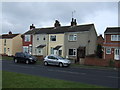
2
Houses on Fitzwilliam Street
Remnants of pre-industrial Swinton.
Image: © Jonathan Thacker
Taken: 2 Feb 2019
0.10 miles
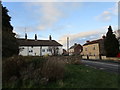
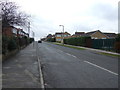
3
Manor Farm Drive Swinton
The next right turn is Piccadilly.
Image: © Steve Fareham
Taken: 10 Feb 2008
0.11 miles

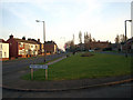
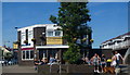
7

Corner of Church Street and Queen Street in Swinton
Image: © Jonathan Clitheroe
Taken: 10 Mar 2017
0.19 miles
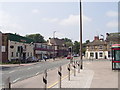
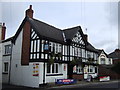
9
The Butchers Arms Swinton
In the 'new' centre of Swinton near the Library.
Image: © Steve Fareham
Taken: 21 Oct 2007
0.19 miles