IMAGES TAKEN NEAR TO
Cliffield Road, MEXBOROUGH, S64 8PX
Introduction
This page details the photographs taken nearby to Cliffield Road, S64 8PX by members of the Geograph project.
The Geograph project started in 2005 with the aim of publishing, organising and preserving representative images for every square kilometre of Great Britain, Ireland and the Isle of Man.

There are currently over 7.5m images from over14,400 individuals and you can help contribute to the project by visiting https://www.geograph.org.uk
Image Map
Images are licensed for reuse under creativecommons.org/licenses/by-sa/2.0
Notes
- Clicking on the map will re-center to the selected point.
- The higher the marker number, the further away the image location is from the centre of the postcode.
Image Listing (23 Images Found)
Images are licensed for reuse under creativecommons.org/licenses/by-sa/2.0
Image
Details
Distance

2
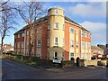
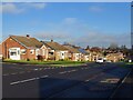
Yorkfield Court
Apartment building on Sidney Street
Image: © Graham Hogg
Taken: 28 Nov 2022
0.12 miles
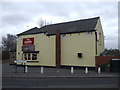
4
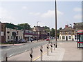
The Butchers Arms Swinton
In the 'new' centre of Swinton near the Library.
Image: © Steve Fareham
Taken: 21 Oct 2007
0.14 miles
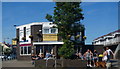
6

Corner of Church Street and Queen Street in Swinton
Image: © Jonathan Clitheroe
Taken: 10 Mar 2017
0.14 miles
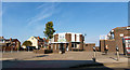
8
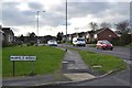
Lime Grove/Muirfield Avenue junction, Swinton
Image: © Neil Theasby
Taken: 5 Dec 2012
0.16 miles
9
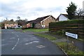
Carnoustie Close, Swinton
For some obscure reason, several of the residential streets in this area of Swinton are named after golf courses. The traditionally hard-working town has never struck me as a hotbed of the golfing fraternity.
Image: © Neil Theasby
Taken: 5 Dec 2012
0.18 miles