IMAGES TAKEN NEAR TO
Duke Street, MEXBOROUGH, S64 8NH
Introduction
This page details the photographs taken nearby to Duke Street, S64 8NH by members of the Geograph project.
The Geograph project started in 2005 with the aim of publishing, organising and preserving representative images for every square kilometre of Great Britain, Ireland and the Isle of Man.

There are currently over 7.5m images from over14,400 individuals and you can help contribute to the project by visiting https://www.geograph.org.uk
Image Map
Images are licensed for reuse under creativecommons.org/licenses/by-sa/2.0
Notes
- Clicking on the map will re-center to the selected point.
- The higher the marker number, the further away the image location is from the centre of the postcode.
Image Listing (9 Images Found)
Images are licensed for reuse under creativecommons.org/licenses/by-sa/2.0
Image
Details
Distance
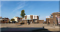
1
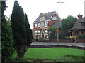
Swinton Carnegie Library
This library has been replaced by a repulsive modern building behind the photographer.
The one in the picture is (I think) converted to flats.
Image: © George Middleton
Taken: 15 Oct 2005
0.15 miles
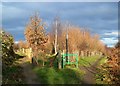
3
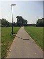
Footpath cycleway to Swinton from Manvers
Used to be just a dirt path.
Image: © Steve Fareham
Taken: 9 Jun 2016
0.23 miles

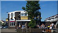
6
The Butchers Arms Swinton
In the 'new' centre of Swinton near the Library.
Image: © Steve Fareham
Taken: 21 Oct 2007
0.24 miles
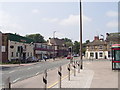
7

Corner of Church Street and Queen Street in Swinton
Image: © Jonathan Clitheroe
Taken: 10 Mar 2017
0.24 miles
8
Three paths diverging at Bow Broom, Swinton
Image: © Neil Theasby
Taken: 5 Dec 2012
0.24 miles
9
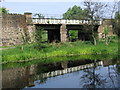
Mexborough - railway bridge over Dearne Canal
Image: © Dave Bevis
Taken: 25 Apr 2011
0.25 miles