IMAGES TAKEN NEAR TO
Brameld Road, MEXBOROUGH, S64 8HJ
Introduction
This page details the photographs taken nearby to Brameld Road, S64 8HJ by members of the Geograph project.
The Geograph project started in 2005 with the aim of publishing, organising and preserving representative images for every square kilometre of Great Britain, Ireland and the Isle of Man.

There are currently over 7.5m images from over14,400 individuals and you can help contribute to the project by visiting https://www.geograph.org.uk
Image Map
Images are licensed for reuse under creativecommons.org/licenses/by-sa/2.0
Notes
- Clicking on the map will re-center to the selected point.
- The higher the marker number, the further away the image location is from the centre of the postcode.
Image Listing (8 Images Found)
Images are licensed for reuse under creativecommons.org/licenses/by-sa/2.0
Image
Details
Distance
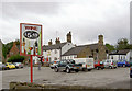
2
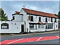
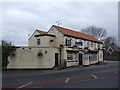
The Kings Head
Public house on Rockingham Road which closed in 2022
Image: © Graham Hogg
Taken: 2 Sep 2024
0.13 miles
7
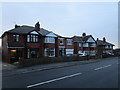
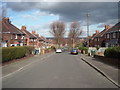
Variations on a suburban theme
Take away the modern extensions and you have three pairs of houses identical in plan but with variations on details of roof, gables, windows and doorways.
Image: © Jonathan Thacker
Taken: 19 Jan 2019
0.19 miles
8
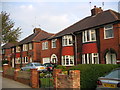
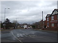
Racecourse Road, Swinton
This is a street of typical 1930's housing.
It is built on a disused racecourse, parts of which can still be followed along pleasant countryside footpaths.
Image: © Christopher Thomas
Taken: 22 Sep 2005
0.25 miles