IMAGES TAKEN NEAR TO
Bridge Street, MEXBOROUGH, S64 8FD
Introduction
This page details the photographs taken nearby to Bridge Street, S64 8FD by members of the Geograph project.
The Geograph project started in 2005 with the aim of publishing, organising and preserving representative images for every square kilometre of Great Britain, Ireland and the Isle of Man.

There are currently over 7.5m images from over14,400 individuals and you can help contribute to the project by visiting https://www.geograph.org.uk
Image Map
Images are licensed for reuse under creativecommons.org/licenses/by-sa/2.0
Notes
- Clicking on the map will re-center to the selected point.
- The higher the marker number, the further away the image location is from the centre of the postcode.
Image Listing (78 Images Found)
Images are licensed for reuse under creativecommons.org/licenses/by-sa/2.0
Image
Details
Distance
1
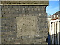
Old milestone plaque
This stone plaque is on the northern parapet of the bridge over the canal in Swinton on the A6022. The bridge was rebuilt in 1889 and 1906. From the style of lettering the plaque may date from that period. Wentworth House is now called Wentworth Woodhouse and was built in the middle of the 18C by the 1st Marquis of Rockingham, a prominent Whig politician. At 606 feet long it has the longest frontage of any house in England.
Image: © Chris Minto
Taken: 1 Feb 2021
0.01 miles
2
Old milestone plaque
A view of the canal bridge in Swinton showing the position of the mileage plaque, From Wentworth House 5 Miles. The short stretch of canal from the Sheffield and South Yorkshire Navigation, Kilnhurst Cut, is about ½ mile long.
Image: © Chris Minto
Taken: 1 Feb 2021
0.01 miles

4
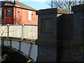
Plaque dated
The north face of the brick parapet of the cast iron canal bridge which has 'From Wentworth House 5 Miles' facing the road. This plaque says the bridge was rebuilt in 1889 and 1906. The cared for towpath is on the far side of the canal.
Image: © Chris Minto
Taken: 1 Feb 2021
0.01 miles
5
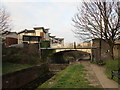
Swinton Bridge and the Dearne and Dove Canal
This canal linked Barnsley with the River Don. Most of its length has been abandoned. https://en.wikipedia.org/wiki/Dearne_and_Dove_Canal
Image: © Jonathan Thacker
Taken: 3 Jan 2019
0.01 miles
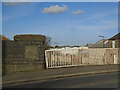
6
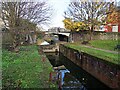
Swinton Lock
The top of a flight of four locks at the junction of the Dearne & Dove Canal with the River Don Navigation. Only a short stretch of the canal to the north of the lock remains in water and the top gate has been replaced by a concrete wall.
Image: © Graham Hogg
Taken: 28 Nov 2022
0.02 miles
7
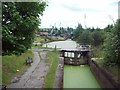
Former Canal Wharf at Swinton Junction
This stretch of water in front of the lock is a surviving fragment of the old Dearne and Dove canal which joined the South Yorkshire Navigation beyond the wharf. This picture was taken from the road over the canal on Bridge Street.
Image: © Jonathan Clitheroe
Taken: 18 Jun 2011
0.03 miles
8
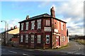
"The Bridge Bar", Swinton
This declining establishment, once a thriving pub, is located on the corner of Dun Street and Bridge Street, Swinton - close to the now derelict Dearne and Dove Canal.
Image: © Neil Theasby
Taken: 5 Dec 2012
0.03 miles
9
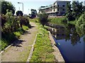
Dearne and Dove Canal
The disused Dearne & Dove canal looking towards the "hump back" bridge that carries the A6022 road. A new waterside flats complex takes shape on the site that was once the Canal Tavern (or Towpath) pub.
Image: © Dave Taylor
Taken: 13 Jul 2008
0.04 miles
10
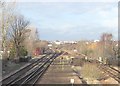
Swinton Town 2nd railway station (site), Yorkshire
Opened in 1899 by the Midland Railway on its line from Rotherham to Leeds, this station replaced the first Swinton station (which coincidentally is also the site of the 3rd and current "Swinton South Yorkshire" station). The second station closed in 1968.
View north from the current station. The station entrance was on Station Street and was still extant when this image was taken (see Image]) - the roof can be seen far left. The two island platforms started where the red structure on the left can be seen, and were accessed by subway.
Image: © Nigel Thompson
Taken: 25 Feb 2014
0.04 miles