IMAGES TAKEN NEAR TO
Racecourse Close, MEXBOROUGH, S64 8EW
Introduction
This page details the photographs taken nearby to Racecourse Close, S64 8EW by members of the Geograph project.
The Geograph project started in 2005 with the aim of publishing, organising and preserving representative images for every square kilometre of Great Britain, Ireland and the Isle of Man.

There are currently over 7.5m images from over14,400 individuals and you can help contribute to the project by visiting https://www.geograph.org.uk
Image Map (Loading...)


Getting Data...Please wait
Leaflet Map data © OpenStreetMap
Images are licensed for reuse under creativecommons.org/licenses/by-sa/2.0
Notes
- Clicking on the map will re-center to the selected point.
- The higher the marker number, the further away the image location is from the centre of the postcode.
Image Listing (4 Images Found)
Images are licensed for reuse under creativecommons.org/licenses/by-sa/2.0
Image
Details
Distance

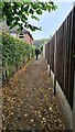
3

Newhill Summit
Parked in Newhill to the north and walked into Wath Wood where the exit onto Boyd Road beside Horse Chestnut tree is the high point with Martin Richardson.
Name: Newhill
Hill number: 16844
Height: 104m / 341ft
Parent (Ma/M): 2810 Black Hill
Section: 36: Lancashire, Cheshire & the Southern Pennines
County/UA: Rotherham (UA)
Class: Tump (100-199m)
Grid ref: SK 43744 99257
Summit feature: ground by tree at end of Boyd Road
Drop: 38m
Col: 66m SK435983
Image: © Rude Health
Taken: 22 Nov 2014
0.18 miles
4
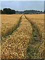
Tractor lines in a wheatfield
The field is on what was in the early 19th century a greyhound racing course
Image: © Graham Hogg
Taken: 2 Sep 2024
0.25 miles