IMAGES TAKEN NEAR TO
The Green, MEXBOROUGH, S64 8EU
Introduction
This page details the photographs taken nearby to The Green, S64 8EU by members of the Geograph project.
The Geograph project started in 2005 with the aim of publishing, organising and preserving representative images for every square kilometre of Great Britain, Ireland and the Isle of Man.

There are currently over 7.5m images from over14,400 individuals and you can help contribute to the project by visiting https://www.geograph.org.uk
Image Map
Images are licensed for reuse under creativecommons.org/licenses/by-sa/2.0
Notes
- Clicking on the map will re-center to the selected point.
- The higher the marker number, the further away the image location is from the centre of the postcode.
Image Listing (5 Images Found)
Images are licensed for reuse under creativecommons.org/licenses/by-sa/2.0
Image
Details
Distance
1
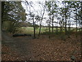
Path and Field Boundary at Creighton Woods
Nature reserve on the western fringes of Swinton.
Image: © Jonathan Clitheroe
Taken: 23 Nov 2015
0.20 miles
2
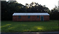
This was the Scout hut
Near the Woodman roundabout, this was the 2nd Don and Dearne Scout hut.
Image: © Steve Fareham
Taken: 21 Oct 2007
0.22 miles
3
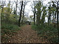
Lych Gate at Swinton Common
The A633 Road passes directly behind this gate.
Image: © Jonathan Clitheroe
Taken: 23 Nov 2015
0.23 miles
5
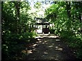
The Sisters Lych Gate
The lych gate marks the entrance to Creighton Woods along the A633 road to Rotherham. The gate was a donation from the local Harrop sisters in 1949.
Image: © Dave Taylor
Taken: 13 Jul 2008
0.24 miles