IMAGES TAKEN NEAR TO
Sivilla Road, MEXBOROUGH, S64 5TY
Introduction
This page details the photographs taken nearby to Sivilla Road, S64 5TY by members of the Geograph project.
The Geograph project started in 2005 with the aim of publishing, organising and preserving representative images for every square kilometre of Great Britain, Ireland and the Isle of Man.

There are currently over 7.5m images from over14,400 individuals and you can help contribute to the project by visiting https://www.geograph.org.uk
Image Map
Images are licensed for reuse under creativecommons.org/licenses/by-sa/2.0
Notes
- Clicking on the map will re-center to the selected point.
- The higher the marker number, the further away the image location is from the centre of the postcode.
Image Listing (25 Images Found)
Images are licensed for reuse under creativecommons.org/licenses/by-sa/2.0
Image
Details
Distance
2
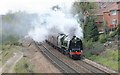
Steam Special passing Kilnhurst
A steam hauled special from Kettering to Scarborough via York is passing Kilnhurst. A passenger service in front has checked the progress of this train.
Image: © roger geach
Taken: 21 Apr 2012
0.13 miles
3

Former video shop on Highthorn Road, Swinton
Now taken over by an Indian family and turned back into a general convenience store.
Image: © Neil Theasby
Taken: 5 Dec 2012
0.14 miles
4

The Old Vicarage, Kilnhurst
Even in an area that was once begrimed and scarred by coal mining, there were always lovely homes like this one - just as there was always a rich history that predated the coal boom.
Image: © Neil Theasby
Taken: 5 Dec 2012
0.15 miles
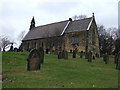
6
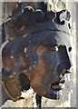
Detail of doorway - St Thomas's Church, Kilnhurst
There's a sadness about this damaged and industry-darkened face that perhaps speaks of the village's former coal mine where countless "accidental" deaths happened.
Image: © Neil Theasby
Taken: 5 Dec 2012
0.17 miles
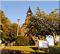
7
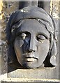
Doorway detail, St Thomas's church, Kilnhurst
There's a sadness about this industry-darkened face that perhaps speaks of the village's former coal mine where countless "accidental" deaths happened.
Image: © Neil Theasby
Taken: 5 Dec 2012
0.17 miles
8
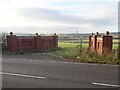
A grand entrance to a field
Presumably intended as the gateway to a development which, for whatever reason, has yet to be built.
Image: © Graham Hogg
Taken: 28 Nov 2022
0.17 miles
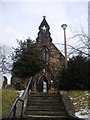
9
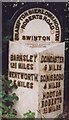
Old Milestone, B6090, Wentworth Road, opposite Pedestrian entrance to Kilnhurst Church
100m NW of junction with Highthor. Located on the South side of road, in verge, almost hidden by hedge. Metal plate attached to stone post, Brayshaw & Booth casting design, 19th century.
Inscription reads: BARNSLEY / 12¾ MILES / WENTWORTH / 5 MILES // DONCASTER / 9 MILES / CONISBORO / 4 MILES / HOOTON / ROBERTS / 1¾ MILES // BRAMPTON BIERLOW & HOOTON / ROBERTS ROAD / SWINTON // BRAYSHAW & BOOTH / MAKERS / LIVERSEDGE
Grade II listed by Historic England. see https://historicengland.org.uk/listing/the-list/list-entry/1286622
Milestone Society National ID: YS_WWHR05
Image: © Christine Minto
Taken: 2 Jan 2006
0.17 miles