IMAGES TAKEN NEAR TO
Vicarage Close, MEXBOROUGH, S64 0ND
Introduction
This page details the photographs taken nearby to Vicarage Close, S64 0ND by members of the Geograph project.
The Geograph project started in 2005 with the aim of publishing, organising and preserving representative images for every square kilometre of Great Britain, Ireland and the Isle of Man.

There are currently over 7.5m images from over14,400 individuals and you can help contribute to the project by visiting https://www.geograph.org.uk
Image Map
Images are licensed for reuse under creativecommons.org/licenses/by-sa/2.0
Notes
- Clicking on the map will re-center to the selected point.
- The higher the marker number, the further away the image location is from the centre of the postcode.
Image Listing (61 Images Found)
Images are licensed for reuse under creativecommons.org/licenses/by-sa/2.0
Image
Details
Distance
1
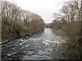
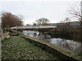
The River Don
Looking downstream from Ferry Boat Lane bridge.
Image: © Jonathan Thacker
Taken: 3 Jan 2019
0.07 miles
2
River Don
View from the bridge over the River Don between Mexborough and Old Denaby.
Image: © Dave Taylor
Taken: 1 Apr 2007
0.08 miles
4

Riverside sculpture
The footbridges over the River Don and Sheffield to Doncaster railway line on the path linking Mexborough with Old Denaby visible in the background.
Image: © Jonathan Thacker
Taken: 3 Jan 2019
0.09 miles
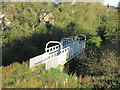
5
Footbridge over the River Don
Adjacent to Mexborough Top Lock.
Image: © Jonathan Thacker
Taken: 3 Jan 2019
0.09 miles
6
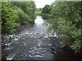
Footbridge View of The River Don
Looking downstream from a footbridge on the outskirts of Mexborough.
Image: © Jonathan Clitheroe
Taken: 18 Jun 2011
0.09 miles
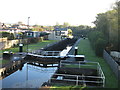
7

Approach to the footbridge of the canal, Top Lock, Mexborough
Image: © Jonathan Thacker
Taken: 3 Jan 2019
0.10 miles

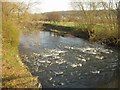
9
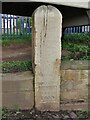
Flood marker stone at former ferry ramp
It was last marked in 1875 but there have been many subsequent floods, most recently in 2007 and 2019, when, according to a passing local, the water would have covered the stone.
Image: © Graham Hogg
Taken: 28 Nov 2022
0.10 miles