IMAGES TAKEN NEAR TO
Clayfield Court, MEXBOROUGH, S64 0JB
Introduction
This page details the photographs taken nearby to Clayfield Court, S64 0JB by members of the Geograph project.
The Geograph project started in 2005 with the aim of publishing, organising and preserving representative images for every square kilometre of Great Britain, Ireland and the Isle of Man.

There are currently over 7.5m images from over14,400 individuals and you can help contribute to the project by visiting https://www.geograph.org.uk
Image Map
Images are licensed for reuse under creativecommons.org/licenses/by-sa/2.0
Notes
- Clicking on the map will re-center to the selected point.
- The higher the marker number, the further away the image location is from the centre of the postcode.
Image Listing (37 Images Found)
Images are licensed for reuse under creativecommons.org/licenses/by-sa/2.0
Image
Details
Distance
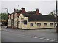
4
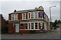
Former Miners Inn on Doncaster Road
Showing position of Postbox No. S64 55.
Image: © JThomas
Taken: 19 Sep 2022
0.05 miles
5
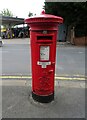
George VI postbox on Doncaster Road
Showing position of Postbox No. S64 55.
Image: © JThomas
Taken: 19 Sep 2022
0.05 miles
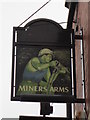
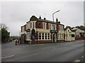
6
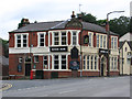
Mexborough - Miners Arms
For an alternative view, please see Image
Image: © Dave Bevis
Taken: 25 Jun 2012
0.05 miles
8

Service station on Doncaster Road
Petrol 164.9p.
Diesel 182.9p.
Image: © JThomas
Taken: 19 Sep 2022
0.06 miles
9
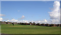
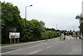
Playing field
Surrounded by a large housing estate.
Image: © Steve Fareham
Taken: 24 Sep 2007
0.10 miles