IMAGES TAKEN NEAR TO
Clayfield Avenue, MEXBOROUGH, S64 0HY
Introduction
This page details the photographs taken nearby to Clayfield Avenue, S64 0HY by members of the Geograph project.
The Geograph project started in 2005 with the aim of publishing, organising and preserving representative images for every square kilometre of Great Britain, Ireland and the Isle of Man.

There are currently over 7.5m images from over14,400 individuals and you can help contribute to the project by visiting https://www.geograph.org.uk
Image Map
Images are licensed for reuse under creativecommons.org/licenses/by-sa/2.0
Notes
- Clicking on the map will re-center to the selected point.
- The higher the marker number, the further away the image location is from the centre of the postcode.
Image Listing (7 Images Found)
Images are licensed for reuse under creativecommons.org/licenses/by-sa/2.0
Image
Details
Distance
1
Closed
What was this, shop, betting office, or?
Image: © Steve Fareham
Taken: 24 Sep 2007
0.16 miles
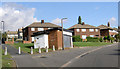
2
Don't Forget the Bathroom
These semi-detached houses appear to have had bathrooms added at a later date. The flat roofed blocks on the sides of the houses are supported on stilts.
Image: © Michael Patterson
Taken: 18 Jul 2006
0.22 miles
3
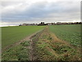
Approaching Mexborough
On a footpath from the River Dearne.
Image: © Jonathan Thacker
Taken: 2 Feb 2019
0.23 miles
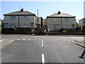
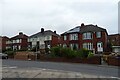
4
Houses on Hirst Gate, Mexborough
Caught in late afternoon sunshine
Image: © Neil Theasby
Taken: 22 Jan 2016
0.24 miles
6
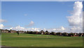
Playing field
Surrounded by a large housing estate.
Image: © Steve Fareham
Taken: 24 Sep 2007
0.24 miles
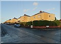
7
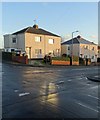
On Hirst Gate, Mexborough
Late afternoon sunshine is reflected on to Hirst gate's junction with Addison Road.
Image: © Neil Theasby
Taken: 22 Jan 2016
0.25 miles