IMAGES TAKEN NEAR TO
Springvale Road, SHEFFIELD, S6 3NT
Introduction
This page details the photographs taken nearby to Springvale Road, S6 3NT by members of the Geograph project.
The Geograph project started in 2005 with the aim of publishing, organising and preserving representative images for every square kilometre of Great Britain, Ireland and the Isle of Man.

There are currently over 7.5m images from over14,400 individuals and you can help contribute to the project by visiting https://www.geograph.org.uk
Image Map
Images are licensed for reuse under creativecommons.org/licenses/by-sa/2.0
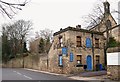
Notes
- Clicking on the map will re-center to the selected point.
- The higher the marker number, the further away the image location is from the centre of the postcode.
Image Listing (121 Images Found)
Images are licensed for reuse under creativecommons.org/licenses/by-sa/2.0
Image
Details
Distance
1

Public Toilets, Commonside
As with many of the public toilets in Sheffield, these were built by Sheffield Corporation Tramways primarily to serve the tram drivers at tram termini. Consequently, they were male toilets. The council later built female toilets next door in the concrete structure just visible.
The Commonside toilets are interesting in that they are built into the base of a hillside. They are essentially underground, and were constructed with bridge-building techniques.
In the picture is a student filmcrew who were making a documentary about public toilets in Sheffield.
Image: © J G Harston
Taken: Unknown
0.11 miles
2
Former St Joseph's House Site, Walkley, Sheffield
The former St Joseph's House lodge is currently home to The Lodge House Natural Health Practice and the former chapel behind it now forms part of a Buddhist community. The area of the city occupied by The University of Sheffield lies 4-5 minutes ahead, by car.
Image: © David Hallam-Jones
Taken: 19 Feb 2018
0.13 miles
3

Commonside, Walkley, Sheffield
Commonside may have gained its title from the habit of herders ‘resting’ their animals on common land in this area whilst in the process of moving them from Stannington and Walkley to the former cattle market near Sheffield's former Victoria Station. (See: https://www.sheffieldhistory.co.uk/forums/topic/16673-baaa/). Although city bound buses join Barber Road ahead - on the horizon - Commonside bears to the right at the same point, passing the side of a jeweller's shop that has blue shutters (a former bank) and it continues uphill towards Crookes and Broomhill.
Image: © David Hallam-Jones
Taken: 19 Feb 2018
0.13 miles
4
Elliot Road leading to Burns Road, off Crookesmoor Road, Crookesmoor, Sheffield
See also ...
Image
Image: © Terry Robinson
Taken: 1 Sep 2012
0.13 miles
5
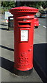
Elizabeth II postbox on Commonside, Sheffield
Postbox No. S10 96.
See Image] for context.
Image: © JThomas
Taken: 30 Jun 2018
0.13 miles
6

Commonside, Sheffield
Showing position of Postbox No. S10 96.
See Image] for postbox.
Image: © JThomas
Taken: 30 Jun 2018
0.13 miles
7
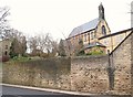
Former St Joseph's House Site, Walkley, Sheffield
This Grade II-listed former St Joseph's Roman Catholic chapel - with school rooms beneath it - was built in 1872, whereas the residential reformatory building attached to it - was opened in a former boarding school building originally called "Howard House". Later, between 1887-1931, these renamed St Joseph's premises became a residential “Industrial School for Roman Catholic Girls”. Even later still later, after a period of closure, it reopened in 1934 as St Joseph’s House for Mentally Handicapped Women and Girls, receiving referrals from across Gt. Britain. By this time additional buildings had been added on site. In 1971 its management was assumed by the Sheffield Health Board, although the Sisters of Charity continued to staff it. In 1974 however, the nuns withdraw their services at the time that the more stringent regulations relating to meeting the educational needs of individuals with learning difficulties came into being. These facilities closed permanently in 1983 and these buildings are currently occupied by a Buddhist community. (See also: http://saintjosephshome.weebly.com/download-the-booklet.html) The South Yorkshire Housing Association had hoped to convert the chapel into apartments but the planning authorities determined that it should remain in use as a religious establishment. The housing association were however, granted permission to build numerous houses on this site, the front doors and windows of which now face the chapel. This is a view from Howard Road looking towards the city centre.
Image: © David Hallam-Jones
Taken: 19 Feb 2018
0.13 miles
8
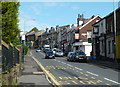
Shops on Barber Road
Looking across Barber Road with Commonside heading away on the right. The jewellers at the top on the corner was formerly a bank.
Image: © Andrew Hill
Taken: 25 Jun 2011
0.14 miles
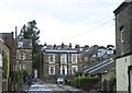
9
Barber Road above Crookesmoor Road
Looking uphill with various shops on the right hand side of the street.
Image: © Andrew Hill
Taken: 25 Jun 2011
0.14 miles
10

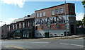
Crookesmoor Vestry Hall, Crookesmoor Road, Crookesmoor, Sheffield - 1
Although this fine 19c building, comprising of the Vestry Hall and Caretaker's House, is 'listed' it is looking very dilapidated. Plans have been put forward to adapt it for Student accommodation but these have not been approved at the time of submission.
The building is directly opposite the former Crookesmoor School, and, I believe, part of the hall was used for some lessons ... possibly music lessons.
See also ...
Image
Image
Image: © Terry Robinson
Taken: 12 Aug 2012
0.16 miles