IMAGES TAKEN NEAR TO
Parkgate, ROTHERHAM, S63 9GW
Introduction
This page details the photographs taken nearby to Parkgate, S63 9GW by members of the Geograph project.
The Geograph project started in 2005 with the aim of publishing, organising and preserving representative images for every square kilometre of Great Britain, Ireland and the Isle of Man.

There are currently over 7.5m images from over14,400 individuals and you can help contribute to the project by visiting https://www.geograph.org.uk
Image Map
Images are licensed for reuse under creativecommons.org/licenses/by-sa/2.0
Notes
- Clicking on the map will re-center to the selected point.
- The higher the marker number, the further away the image location is from the centre of the postcode.
Image Listing (12 Images Found)
Images are licensed for reuse under creativecommons.org/licenses/by-sa/2.0
Image
Details
Distance
5
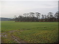
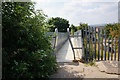
Harry Ottley Plantation
Plantation of trees near Goldborough, with part of a disused coalmining spoil heap in the left background.
Image: © Robert Neilson
Taken: 20 Feb 2007
0.18 miles
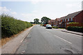
7

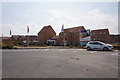
Regeneration east of Goldthorpe
The concrete visible behind the trees formed part of the rail facility serving the former Goldthorpe Colliery - indeed, on the right one rail can be seen still in place. The colliery stood to the right of this scene. To the left, recently built houses are indicative of modest economic revival in recent years.
Image: © David Wilkinson
Taken: 22 Jul 2007
0.21 miles
8
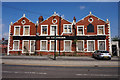
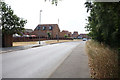
The Goldthorpe, Doncaster Road, Goldthorpe
For many years on New Years Day there was a 16 mile walk held here called The Hangover Hike. I believe that I did it around 15 times.
Image: © Ian S
Taken: 7 Jul 2018
0.22 miles
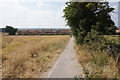
10
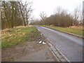
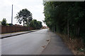
Access road near Harry Ottley Plantation, Goldthorpe
This field access road was formerly part of the A635 road from Barnsley to Doncaster, just to the East of the former mining village of Goldthorpe. When the Dearne Valley Parkway was constructed to improve sections of the A635, one of the places it by-passed was Goldthorpe and this section was made redundant as a through road when a junction from the former A635 road out of Goldthorpe was constructed to join the Eastern end of the Dearne Valley Parkway from a point near its horizon in this photograph. The redundant section of road is a dead end just behind the photographer's position.
Image: © Robert Neilson
Taken: 20 Feb 2007
0.23 miles