IMAGES TAKEN NEAR TO
Boyd Road, ROTHERHAM, S63 7TU
Introduction
This page details the photographs taken nearby to Boyd Road, S63 7TU by members of the Geograph project.
The Geograph project started in 2005 with the aim of publishing, organising and preserving representative images for every square kilometre of Great Britain, Ireland and the Isle of Man.

There are currently over 7.5m images from over14,400 individuals and you can help contribute to the project by visiting https://www.geograph.org.uk
Image Map
Images are licensed for reuse under creativecommons.org/licenses/by-sa/2.0
Notes
- Clicking on the map will re-center to the selected point.
- The higher the marker number, the further away the image location is from the centre of the postcode.
Image Listing (13 Images Found)
Images are licensed for reuse under creativecommons.org/licenses/by-sa/2.0
Image
Details
Distance
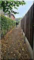
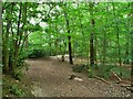
1

Newhill Summit
Parked in Newhill to the north and walked into Wath Wood where the exit onto Boyd Road beside Horse Chestnut tree is the high point with Martin Richardson.
Name: Newhill
Hill number: 16844
Height: 104m / 341ft
Parent (Ma/M): 2810 Black Hill
Section: 36: Lancashire, Cheshire & the Southern Pennines
County/UA: Rotherham (UA)
Class: Tump (100-199m)
Grid ref: SK 43744 99257
Summit feature: ground by tree at end of Boyd Road
Drop: 38m
Col: 66m SK435983
Image: © Rude Health
Taken: 22 Nov 2014
0.08 miles


6
Wath Wood Hospital
Secure psychiatric facility pictured from a footpath near Wath Wood Houses.
Image: © Jonathan Clitheroe
Taken: 23 Nov 2015
0.21 miles
7
Site of Waterloo Pottery
Building and pond on the site of the pottery which produced earthenware and porcelain products under the stewardship of the Wentworth Estate. After the pottery closed the surviving kiln (situated beyond the pond) was used as a smallpox isolation hospital.
Image: © Jonathan Clitheroe
Taken: 23 Nov 2015
0.21 miles
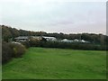
8
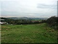
Fields at Wath Wood
The Hoober Stand can be seen here on the middle horizon as well as part of Wathwood Hospital on the left.
Image: © Jonathan Clitheroe
Taken: 23 Nov 2015
0.22 miles

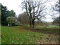
10
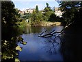
Pottery Pond
The pond is one of the only remains (along with the Waterloo kiln and a couple of buildings which are now private residences) from the once famous Rockingham Pottery which closed in the 1840's. The pond provided the large quantities of water required by the pottery.
Image: © Dave Taylor
Taken: 4 Oct 2009
0.23 miles